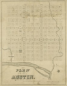
Waller Plan
It was commissioned in 1839 by the government of the Republic of Texas and developed by Edwin Waller, a Texian revolutionary and politician who would later become Austin's first mayor.
Texas President Mirabeau B. Lamar instructed the committee to consider a site along the north bank of the Colorado River that he had visited the previous year.
[5] The central street of the city, Congress Avenue, ran northward from the bank of the river along a natural valley to the Capitol Square hilltop.
[10] The plan also designated spaces for a hospital, an academy and university, churches, a courthouse and jail, an armory, and a penitentiary.
[5] With the surveying and grid plan completed, Waller and his associates drew up a plat dividing the city blocks into land lots.
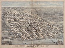
It wasn't until the 1870s, with the arrival of the Houston and Texas Central Railway and the economic boom of the post-war Reconstruction era, that Austin expanded significantly beyond the bounds of the 1839 Waller Plan.
[13]: 4 It also noted the good condition of the three surviving park squares from the Waller Plan and their value to the city as "beauty spots and breathing spaces".