Walteria, Torrance
[2][3] Weston's land included what is now Torrance Airport and was "bordered by what is now Madison on the west, Sepulveda Boulevard to the north, the Lomita line on the east, and the Palos Verdes foothills to the south.
[4] Walters moved to the California farming area in the 1880s and built a stagecoach stop on the Redondo–Wilmington road connecting the salt works in Redondo Beach with the harbor in San Pedro.
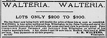
[5] In 1888, real estate developers advertised Walteria as a subdivision of Meadow Park that offered "pure air and delightful scenery" to potential buyers.
"[7] According to a 1949 history of Rancho Palos Verdes, "On the northern side of the ranch, abortive cities of grand scale [were] plotted, including the subdivision named Walteria on the property of [N.
Attractive as the plans appeared, the construction of these works was not consummated before the collapse of the boom, so the ranch lands remained planted in grain and devoted to grazing of sheep, except for a few scattered sales in the different tracts, and the growing San Pedro town.
"[3] One 1890 account described Walteria as one of 60 paper towns laid out in the Greater Los Angeles era in 1887–88 but not substantially built: "The plowshare has passed over their ruins, and barley grows in their deserted streets.
[2] During World War II, a citizens committee worked to supply the library with books in honor of the 111 people from Walteria serving the armed forces.
[15] For a time the Begonia Farm shared a lot and a mutually beneficial association with the Smith Brothers Fish Shanty restaurant.
[16] The Indian Village restaurant sold "firewater" and denominated their menu prices in "wampum" and called its meeting areas "pow-wow rooms".
[16] The Palos Verdes Bird Farm opened in Walteria in 1952 at a site on Pacific Coast Highway between Crenshaw and Hawthorne Boulevards.
[18] In 1964 it suffered a fire that killed almost 1,000 birds, including a greater sulphur-crested cockatoo named Tommy who had worked in film and television.