Weather satellite
Satellites are mainly of two types: polar orbiting (covering the entire Earth asynchronously) or geostationary (hovering over the same spot on the equator).
[1] While primarily used to detect the development and movement of storm systems and other cloud patterns, meteorological satellites can also detect other phenomena such as city lights, fires, effects of pollution, auroras, sand and dust storms, snow cover, ice mapping, boundaries of ocean currents, and energy flows.
[4] It was designed to measure cloud cover and resistance, but a poor axis of rotation and its elliptical orbit kept it from collecting a notable amount of useful data.
TIROS paved the way for the Nimbus program, whose technology and findings are the heritage of most of the Earth-observing satellites NASA and NOAA have launched since then.
Polar orbiting satellites such as QuikScat and TRMM began to relay wind information near the ocean's surface starting in the late 1970s, with microwave imagery which resembled radar displays, which significantly improved the diagnoses of tropical cyclone strength, intensification, and location during the 2000s and 2010s.
Meteosat-8, the first MSG satellite, was launched in 2002 on an Ariane-5 launcher, carrying the Spinning Enhanced Visible and Infrared Imager (SEVIRI) and Geostationary Earth Radiation Budget (GERB) instruments, along with payloads to support the COSPAS-SARSAT Search and Rescue (SAR) and ARGOS Data Collection Platform (DCP) missions.
SEVIRI provided an increased number of spectral channels over MVIRI and imaged the full-Earth disc at double the rate.
This operational satellite - which forms the space segment of the EUMETSAT Polar System (EPS) - built on the heritage from ESA's ERS and Envisat experimental missions, and was followed at six-year intervals by Metop-B and Metop-C - the latter launched from French Guyana in a "Europeanised" Soyuz.
The satellite service module is based on the SPOT-5 bus, while the payload suite is a combination of new and heritage instruments from both Europe and the US under the Initial Joint Polar System agreement between EUMETSAT and NOAA.
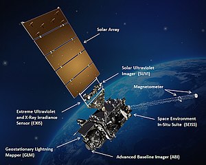
[8] The Meteosat Third Generation (MTG) programme launched its first satellite, Meteosat-12, in 2022, and featured a number of changes over its predecessors in support of its mission to gather data for weather forecasting and climate monitoring.
UVN is part of the European Commission's Copernicus programme and fulfils the Sentinel-4 mission to monitor air quality, trace gases and aerosols over Europe hourly at high spatial resolution.
Two MTG satellites - one Imager and one Sounder - will operate in close proximity from the 0-deg geostationary location over western Africa to observe the eastern Atlantic Ocean, Europe, Africa and the Middle East, while a second imager satellite will operate from 9.5-deg East to perform a Rapid Scanning mission over Europe.
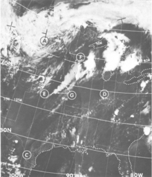
Some of these channels include:[9][10] Visible-light images from weather satellites during local daylight hours are easy to interpret even by the average person, clouds, cloud systems such as fronts and tropical storms, lakes, forests, mountains, snow ice, fires, and pollution such as smoke, smog, dust and haze are readily apparent.
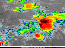
Infrared satellite imagery can be used effectively for tropical cyclones with a visible eye pattern, using the Dvorak technique, where the difference between the temperature of the warm eye and the surrounding cold cloud tops can be used to determine its intensity (colder cloud tops generally indicate a more intense storm).
[12] Infrared pictures depict ocean eddies or vortices and map currents such as the Gulf Stream which are valuable to the shipping industry.
Fishermen and farmers are interested in knowing land and water temperatures to protect their crops against frost or increase their catch from the sea.
Using color-digitized techniques, the gray shaded thermal images can be converted to color for easier identification of desired information.
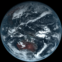
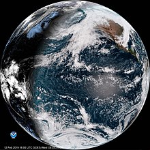
Because of this orbit, they remain stationary with respect to the rotating Earth and thus can record or transmit images of the entire hemisphere below continuously with their visible-light and infrared sensors.
The news media use the geostationary photos in their daily weather presentation as single images or made into movie loops.
Polar orbiting weather satellites circle the Earth at a typical altitude of 850 km (530 miles) in a north to south (or vice versa) path, passing over the poles in their continuous flight.
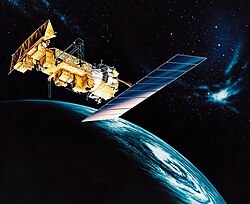
The United States Department of Defense's Meteorological Satellite (DMSP) can "see" the best of all weather vehicles with its ability to detect objects almost as 'small' as a huge oil tanker.
Snowfield monitoring, especially in the Sierra Nevada, can be helpful to the hydrologist keeping track of available snowpack for runoff vital to the watersheds of the western United States.
In addition to reducing visibilities and causing respiratory problems, sand clouds suppress hurricane formation by modifying the solar radiation balance of the tropics.