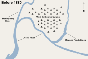
West Melbourne Swamp
[1] Surveyor Charles Grimes observed the swamp when he climbed a nearby hill during his 1803 voyage to chart Port Philip Bay.
[3] The lagoon was also described as; having a bottom of solid blue clay and laying at the high water level while the flats surrounding it were about one metre above high tide... [4] Because of its distance from the city and its unsuitability for residential development, the land in the area became the location for many noxious industries, such as abattoirs, fellmongeries, tanneries and rubbish depots.
The Commission recommended some residential development to the immediate west of the city, the reservation of areas along the Yarra River for docks, warehouses and industry, with the rest of the land being given over to agriculture and parkland.
[5] Drainage of the swamp was considered from the mid-19th century, but did not commence in earnest until about 1877, when a steam-operated pump was set up near Brown's Hill at South Kensington, and drains dug along Swamp Road, which was later reconstructed as Dynon Road, connecting to West Melbourne.
In 1907, the Footscray contractor, Michael Walsh, won a large state government contract to undertake further drainage.