Westward expansion trails
In the history of the American frontier, pioneers built overland trails throughout the 19th century, especially between 1840 and 1847 as an alternative to sea and railroad transport.
These immigrants began to settle much of North America west of the Great Plains as part of the mass overland migrations of the mid-19th century.
Settlers emigrating from the eastern United States did so with various motives, among them religious persecution and economic incentives, to move from their homes to destinations further west via routes such as the Oregon, California, and Mormon Trails.
Legislation like the Donation Land Claim Act and significant events like the California Gold Rush further encouraged settlers to travel overland to the west.
The history of these trails and the settlers who traveled them have since become deeply embedded in the culture and folklore of the United States as some of the most significant influences to shape the content and character of the nation.
Travelers may loosely follow various routes of the emigrant trails on modern highways through the use of byway signs across the western states.
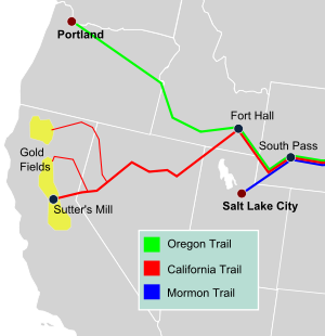
From their confluence there the combined trails followed in succession the Platte, North Platte, and Sweetwater rivers westward across the full widths of Nebraska and Wyoming, and crossed the continental divide south of the Wind River Range through South Pass in southwestern Wyoming.
For all pioneers, the scarcity of potable water and fuel for fires was a common brutal challenge on the trip, which was exacerbated by the wide ranging temperature changes common to the mountain highlands and high plains where a daylight reading in the eighties or nineties can drop precipitously to a frigid seeming nighttime temperature in the low 40s.
This route, not closed to travel in winter, permitted travelers coming to New Mexico Territory on the Santa Fe Trail or on the San Antonio-El Paso Road developed in 1849, across West Texas to El Paso where it followed the El Camino Real de Tierra Adentro north to link up to the Cooke's Wagon Road/Southern Emigrant Trail at the cutoff through the San Diego Crossing.
The first significant use of the route was by parties of Forty-Niners late in 1849, and by some Mormon trains, to avoid crossing the snow bound Sierra Nevada Mountains by linking up with the Old Spanish Trail in southern Utah and closely following it, with alterations to the route of the mule trails only to allow wagons to traverse it for the first time.
Soon afterward it was the route Mormon settlers followed to southwestern Utah, a mission in Las Vegas and a settlement in San Bernardino, California.
Pioneered in 1821 by William Becknell, it served as a vital commercial highway until the introduction of the railroad to Santa Fe in 1880.
Santa Fe was near the end of the El Camino Real de Tierra Adentro which carried trade from Mexico City.
The route skirted the northern edge and crossed the northwestern corner of Comancheria, the territory of the Comanche, who demanded compensation for granting passage to the trail, and represented another market for American traders.
By the 1840s, trail traffic along the Arkansas Valley was so heavy that bison herds could not reach important seasonal grazing land, contributing to their collapse which in turn hastened the decline of Comanche power in the region.
After the U.S. acquisition of the Southwest ending the Mexican–American War, the trail helped open the region to U.S. economic development and settlement, playing a vital role in the expansion of the U.S. into the lands it had acquired.
The Old Spanish Trail witnessed a brief but furious heyday between 1830 and 1848 as a trade route linking Santa Fe, New Mexico and Los Angeles, California.
The South or Main Branch headed northwest past Colorado's San Juan mountains to near Green River, Utah.
It was the only practical way for settlers in wagons without tools, livestock, or supplies to cross the mountains and usually thought critical to the settlement of the American West.
Children were crushed under the covered wagon wheels, people drowned in rivers, were lost, starved, killed by Native Americans (very few settlers), froze to death, trampled by buffalo, or shot by accident.
During summer, the trail was crowded with wagon trains, army units, missionaries, hunting parties, traders, and even sightseeing tours.
Today, over 1,000 miles of trail ruts and traces can still be seen in the vast undeveloped lands between Casper, Wyoming, and the West Coast.
Generally following pre-existing routes, the trail carried tens of thousands of Mormons to a new home and refuge in the Great Basin.
The Mormon settlers shared similar experiences with others traveling west: the drudgery of walking hundreds of miles, suffocating dust, violent thunderstorms, mud, temperature extremes, bad water, poor forage, sickness, attacks from indians, and death.
As it was also motivated by a desire to maintain a religious and cultural identity it was necessary to find an isolated area where they could permanently settle and practice their religion in peace.