Wichita Mountains
Fort Sill, home of the U.S. Army Field Artillery School, occupies a large portion of the southeastern end of the mountains.
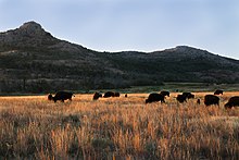
The Wichita Mountains National Wildlife Refuge, a favorite for hikers and rock climbers in the region, is located adjacent to Cache, Medicine Park, Indiahoma, and historic Meers, and is a short drive from Lawton and Walters.
[4][5] A paved road leads to the summit of Mount Scott, offering views of the granite promontories to the west, the wind farm on the Slick Hills to the north, the lakes to the south and east, Fort Sill, and Lawton.
[6] When the area was part of Indian reservations and therefore off-limits to non-Native Americans, the Wichita Mountains were rumored to contain rich gold deposits.
When the area was first opened up for settlement, many prospectors staked mining claims, and towns were laid out to serve the presumed bonanzas, but no economic deposits were found.
Exposure of these fossil mountains is greatest towards the southeast; much of the western part of the Permian range remains buried under sandstones and mudstones.
The geologic history of the region began with the deposition of late Precambrian to early Cambrian sandstones collectively known as the Tillman metasedimentary group.
[9] These are poorly exposed, with the exception of a large diabase dike in the Mount Scott Granite revealed during the recent widening of Oklahoma State Highway 49, just west of Interstate 44.
During the Pennsylvanian Period (330–290 million years ago) the region was subjected to intense pressure during the continental collision or orogeny which produced the Ouachita Mountains to the east.
[17] This resulted in faulting and folding striking along a WNW direction and includes the Arbuckle and Wichita Mountains of southern Oklahoma and the Amarillo Uplift of the Texas Panhandle.
[18] This uplift locally created rugged mountains reduced by erosion to their present state largely during the Pennsylvanian and Permian Periods.
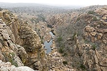
Extensive weathering produced the tors of the Charon Gardens region and the "river" of boulders that descends the west slope of Mount Scott.
Likewise, weathering produced the bowling-ball sized boulders in the Permian Post Oak Conglomerate locally found in and around the mountains.