Landform
Landforms are categorized by characteristic physical attributes such as elevation, slope, orientation, structure stratification, rock exposure, and soil type.
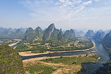
Gross physical features or landforms include intuitive elements such as berms, mounds, hills, ridges, cliffs, valleys, rivers, peninsulas, volcanoes, and numerous other structural and size-scaled (e.g. ponds vs. lakes, hills vs. mountains) elements including various kinds of inland and oceanic waterbodies and sub-surface features.
Elementary landforms (segments, facets, relief units) are the smallest homogeneous divisions of the land surface, at the given scale/resolution.
A number of factors, ranging from plate tectonics to erosion and deposition (also due to human activity), can generate and affect landforms.
In onomastic terminology, toponyms (geographical proper names) of individual landform objects (mountains, hills, valleys, etc.)
[4] Landforms may be extracted from a digital elevation model (DEM) using some automated techniques where the data has been gathered by modern satellites and stereoscopic aerial surveillance cameras.