Southwest Territory
The establishment of the Southwest Territory followed a series of efforts by North Carolina's trans-Appalachian settlers to form a separate political entity, initially with the Watauga Association, and later with the failure of the additional proposed western State of Franklin.
North Carolina ceded these lands in April 1790 as payment of obligations owed to the new central federal government.
The Southwest Territory's residents welcomed the cession, believing the federal government would provide better protection from native Indian hostilities.
Along with Blount, a number of individuals who played prominent roles in early Tennessee history served in the old Southwest Territory's administration.
The colony was established on Cherokee-owned land in which the Watauga and Nolichucky settlers had negotiated a 10-year lease directly with the Indians.
In March 1775, land speculator and North Carolina judge Richard Henderson met with more than 1,200 Cherokees at Sycamore Shoals.
Nevertheless, at the onset of the American War for Independence in 1776, the settlers, who vigorously supported the Patriot cause, organized themselves into the "Washington District" and formed a committee of safety to govern it.
In September 1780, a large group of trans-Appalachian settlers, led by William Campbell, John Sevier and Isaac Shelby, assembled at Sycamore Shoals in response to a British threat to attack frontier settlements.
John Sevier was named governor and the area began operating as an independent state not recognized by the Congress of the Confederation.
Many Overmountain settlers, led by John Tipton, remained loyal to North Carolina, and frequently quarreled with the Franklinites.
[7] On December 22, the state legislature voted to cede the Overmountain settlements as payment of its obligations to the new federal government.
[9] On May 26, 1790, Congress passed an act organizing the new cession as the "Territory of the United States South of the River Ohio", which consisted of modern Tennessee, with the exception of later minor boundary changes.
William Blount, a Constitutional Convention delegate and former state legislator who had championed the causes of western settlers, was supported by key North Carolina politicians such as Hugh Williamson, Timothy Bloodworth, John B. Ashe and Benjamin Hawkins.
[1] In September 1790, Blount visited Washington at Mount Vernon, and was sworn in by Supreme Court justice James Iredell.
He then moved to the new territory, where he set up a temporary capital at Rocky Mount, the home of William Cobb in Sullivan County.
In December, he made the dangerous trip across Indian territory to the Mero District, where he likewise issued appointments, before returning to Rocky Mount by the end of the year.
[10] In the 1790 United States census, 7 counties in the Southwest Territory reported the following population counts:[11] Residents of the Southwest Territory initially welcomed federal control, believing the federal government would provide better protection from hostile Indians than North Carolina's distant government to the east.
[1] The following year, Blount negotiated an agreement clarifying land boundaries with the Chickasaw, who controlled what is now West Tennessee.
In spite of growing impatience from frontiersmen, Secretary of War Knox refused to authorize an invasion of Indian territory.
[1] In September 1794, Robertson, without authorization from Knox, dispatched a mounted American force under James Ore which destroyed the Chickamauga towns of Nickajack and Running Water.
[1] The defeat of northern tribes at the Battle of Fallen Timbers in August 1794, the destruction of Nickajack and Running Water, and the resolving of boundary disputes between the United States and Spain led to a decline in hostile Indian attacks.
[1] In November 1794, Blount negotiated an end to the Cherokee–American wars at the Tellico Blockhouse, a federal outpost south of Knoxville.
[1] A special session of the assembly on June 29, 1795, called for a census to be taken the following month to determine if the territory's population had reached the 60,000 threshold required for statehood.
John Sevier was elected governor, the first Tennessee General Assembly convened in March 1796, and Blount notified the Secretary of State, Timothy Pickering, that the territorial government had been terminated.
[8] Both ordinances provided for freedom of religion and the sanctity of contracts, barred legal primogeniture, and encouraged the establishment of schools and respect for the liberty of the Indians.
[9] The governor was responsible for appointing the lower territorial administrative officers, including attorneys general, justices of the peace, registers, and court clerks.
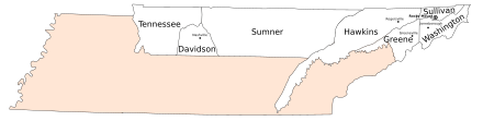
Its members were John Tipton (Washington), George Rutledge (Sullivan), Joseph Hardin (Greene), William Cocke (Hawkins), Joseph McMinn (Hawkins), Alexander Kelly (Knox), John Beard (Knox), Samuel Wear (Jefferson), George Doharty (Jefferson), David Wilson (Sumner), Dr. James White (Davidson) and James Ford (Tennessee County).
[15] Along with hearing criminal and civil cases, courts were responsible for licensing ferries, regulating taverns, and designating public gristmills.
[18] The Southwest Territory covered 43,000 square miles (110,000 km2),[2] consisting of what is now Tennessee, with the exception of a few minor boundary changes resulting from later surveys.
[1] The territory's 1795 census showed a total population of 77,262 inhabitants, including 10,613 slaves and 973 free persons of color.