Will Rogers Turnpike
The Will Rogers Turnpike is a controlled-access toll road in the northeast portion of the U.S. state of Oklahoma.
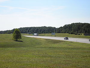
The turnpike is 88.5 miles (142.4 km) long and costs $4.75 (for a two-axle vehicle) to drive one way.
North of the Pine Street interchange, the highway curves to a more northeast course, crossing the Verdigris River.
The first interchange in Ottawa County lies northeast of Afton; here, motorists can access US-59, US-60, and US-69.
[4] Because the Will Rogers Turnpike was built prior to authorization of the Interstate Highway System (in 1956), it uses a different set of design standards than today's.
The original route of the Turnpike continued straight into and through Tulsa, becoming Skelly Drive in town (where tolls are not charged).
The original interchange was changed due to numerous difficulties for semis trying to merge into the single lane going to I-44 and Route 66.
The remaining pavement of the old alignment is now used as a training ground for the Oklahoma Highway Patrol, among others.
A two-axle vehicle currently pays $8.75 with PlatePay ($4.50 with Pikepass) to drive the full length of the Turnpike.
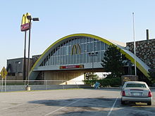
The main feature of this service plaza is a 29,135-square-foot (2,706.7 m2) McDonald's bridge restaurants spanning the turnpike.
Customers can view the traffic passing beneath the restaurant from the dining area through windows overlooking the highway.
The architecture of the McDonald's building is dominated by golden arches on both sides of the building that appear from a distance to be not only the corporate symbol of the chain but the primary supports for a steel arch bridge structure over the turnpike.