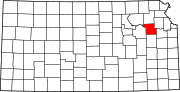
Willard, Kansas
In 1887, the Chicago, Kansas and Nebraska Railway built a main line from Topeka through Willard to Herington.
In the early 1920s, Willard boasted a population of over 300 and was a major cattle shipping point for this region.
During the Great Depression of the 1930s, many businesses closed and the railroad declined in importance.
[6] According to the United States Census Bureau, the city has a total area of 0.11 square miles (0.28 km2), all land.
[7] The climate in this area is characterized by hot, humid summers and generally mild to cool winters.
[8] Willard is part of the Topeka, Kansas Metropolitan Statistical Area.
There were no families and 5.7% of the population living below the poverty line, including no under eighteens and 9.1% of those over 64.
The community is served by Kaw Valley USD 321 public school district.