William Roy
Major-General William Roy FRS FSA FRSE (4 May 1726 – 1 July 1790) was a Scottish military engineer, surveyor, and antiquarian.
He was an innovator who applied new scientific discoveries and newly emerging technologies to the accurate geodetic mapping of Great Britain.
His maps and drawings of Roman archaeological sites in Scotland were the first accurate and systematic study of the subject, and have not been improved upon even today.
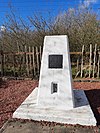
The inscription reads "Here stood Miltonhead the birthplace of Major-General William Roy 4th May 1726 - 30th June 1790 from whose military map of Scotland made in 1747 - 1755 grew the Ordnance Survey of Great Britain".
In 1747 Lieutenant-Colonel David Watson, Deputy Quartermaster-General, proposed the compilation of a map of the Scottish Highlands following the Jacobite rising of 1745.
Roy was without any military rank at this time[16] but Watson appointed him as an assistant to the quartermaster to provide him some seniority over the group of (typically) six soldiers who travelled with him: an NCO, two end markers, two chainmen and a batman.
[17] Eventually there were six teams conducting surveys by traverses of the country with the objects to the side of the line recorded by sketches and compass directions.
At the same time he was appointed as a practitioner-engineer, the lowest rank in the Board of Ordnance survey department, and ensign in the Corps of Engineers.
[11] Thereafter his promotion was rapid, and by the end of the war in 1763 Roy was a lieutenant colonel in the regiment and director of the engineers of the Board of Ordnance as well as being the deputy quartermaster general for Germany.
This work, which took him to many parts of Britain and abroad (Ireland and Gibraltar), is recorded in the many plans and sketch maps of districts that are now lodged at the British Library.
In 1783 Cassini de Thury addressed a memoir to the Royal Society in which he expressed grave reservations of the measurements of latitude and longitude which had been undertaken at Greenwich Observatory.
[28] After a preliminary survey by Roy and three other members of the Society on 16 April, they found a suitable location for the starting baseline on Hounslow Heath, between King's Arbour and Hampton Poor-house just over 5 miles to the south-east.
It was the intention to measure more accurately with a set of three deal rods about 20 ft. in length but their use had to be abandoned because of their susceptibility to lengthen and shorten in wet weather.
The precision of this baseline measurement far exceeded any previous attempts, and in recognition Roy was awarded the Copley medal by the Royal Society in 1785.
The final report of 1790[25] presents figures for the distance between Paris and Greenwich as well as the precise latitude, longitude and height of the British triangulation stations.
During the Scottish Survey, Roy took careful note of the locations of ancient Roman remains, primarily military camps, wherever he encountered them and these were all marked precisely on the map sheets.
This was the beginning of a lifelong interest in ancient Scottish history which he pursued whenever he was travelling the country in his capacity as Surveyor General.
Roy was the first to systematically map the Antonine Wall and provide accurate and detailed drawings of its remains, an effort undertaken in 1764.
This was due to his belief that the spurious text of Charles Bertram De Situ Britanniae was a genuine work, a view shared by virtually all of his contemporaries.
Roy consequently adjusted his perspective to be consistent with the history as told in the fraud, causing his own conclusions to be without a valid foundation.
Much of Roy's research was devoted to the attempt to follow fictitious journeys throughout Scotland that were described in De Situ Britanniae.


