Wishbone scarp
[2] Both pass through the Louisville hotspot chain, and in so doing lose some continuity but the western Wishbone scarp can be mapped all the way to the continental crust of the north east Chatham Rise.
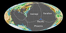
[10] The Cretaceous oceanic crust west of the scarps is the southern flank of an historic rise that had the now fossil Osbourn Trough as its spreading axis.
[15] The breakup of Gondwana, and resulting forces on the former Phoenix Plate as the large igneous province of the Ontong Java–Manihiki–Hikurangi plateau split up, with separation into what are now the Manihiki and Hikurangi plateaus, are likely key to the formation of the Wishbone scarp.
[17] The Hikurangi Plateau initially subducted under onshore continental crust, but this process stalled between 105 and 100 million years ago and rotation started to occur which has led to the present and still active young geology of New Zealand.
[1] At its southern end, the West Wishbone scarp matches the eastern border of the Hikurangi Plateau, which as part of the continental crust of Zealandia lies east of, and beneath, New Zealand, and the Chatham Rise.
[19] Strike-slip motion along the West Wishbone scarp initiated as a consequence of the slowing of spreading at the Osbourn Trough about 105 million years ago.