Witham Navigable Drains
A major advance was made in the seventeenth century, when Adventurers built drains in return for rights to some of the reclaimed land, but the success was short-lived, as Fenmen and Commoners rioted in 1642 and destroyed the works.
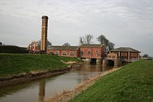
Sensitive restoration of some of the pumping stations in the 1980s and 1990s resulted in the Witham Fourth District IDB being given a Design Award.
Many of the structures built as part of Rennie's upgrade in the early 1800s survive in near-original condition, and are Grade II listed.
[2] Most of the fens were extra-parochial, consisting of a huge common, on which people from the surrounding villages had grazing rights.
While there is evidence for occupation of the region by Romans, Saxons, Danes and Normans, the first references to flood defences occur in the 11th and 12th centuries, when monks built a sea bank to hold back tides from their agricultural land.
A sluice was constructed in 1142 on the River Witham to improve it for navigation, and Commissions of Sewers were appointed in the 13th century.
Floods in 1394 resulted in a decision to rebuild a floodgate at Waynflete, with the villages affected paying the construction costs.
The first Maud Foster drain was cut in 1568, from Cowbridge to The Haven,[7] but in 1631 it was inadequate, as there was widespread flooding in both fens, which resulted in Sir Anthony Thomas, John Warsopp and other Adventurers being commissioned to enlarge the Maud Foster drain and build a new outfall where it discharged into The Haven.
[8] Not everyone was in favour of the work, as in 1642 many of those who formerly had common rights to the land formed a mob, and destroyed sluices, houses and crops.
Legal action followed, which the Commoners won, with the result that the Court of Sewers were again responsible for drainage matters, but the ditches and sluices remained ruined for many year.
As a result, a sluice was built on Valentine's Drain, which maintained the water level in the East Fen at a height sufficient to allow the Fenmen to continue their way of life.
With Sir Joseph Banks of Revesby Abbey pushing for a solution, the civil engineer John Rennie was asked to produce a plan for the drainage of both fens.
He suggested catchwater drains to collect the runoff from the Wolds to prevent it entering the fens, and a new tidal sluice at Hobhole, closer to the Wash than the Maud Foster outlet.
In order to keep the foundations for the sluice free from water, they were pumped out by a Boulton & Watt steam engine, rated at 6 hp (4.5 kW).
The machine lasted until at least 1814, just three years before the first permanent steam pumping station was built at Sutton St. Edmund in South Holland.
This was probably built by John Parkingson in the early 19th century, to provide canal access to the village which he hoped would become a market town.
The tunnels were completed in 1821, and were entirely hidden until the construction of Lade Bank pumping station in 1867 lowered the water levels.
c. cxxxviii) authorised the construction of a steam-driven pumping station at Lade Bank, which was completed by September, to resolve this problem.
A pair of engines was rated at 240 horsepower (180 kW) and could pump 350 tons per minute (514 Megalitres per day (Mld)).
The disastrous North Sea flood of 1953, which affected so much of the East Coast of England had little effect in the Fourth District.
The pumping station at Thorpe Culvert was managed by the Anglian Water Authority, but a replacement in 1983 was partly funded by the Fourth District.
[20] Anton's Gowt lock is 75 by 18 feet (22.9 by 5.5 m), but although a boat of this size could pass through it, most of the drains are inaccessible to such large craft.
The only other working lock is at Cowbridge, which is 70 by 10 feet (21.3 by 3.0 m), and gives access to the Maud Foster drain, enabling boats to visit the centre of Boston.
Cruising can be hazardous due to weed growth, which forms a dense blanket in some channels, but a drain that was formerly virtually un-navigable may suddenly be cleared to improve its drainage performance and become navigable again.
The relative isolation of much of the Witham Navigable Drains has resulted in many of the structures which were built as part of Rennie's upgrade in the early 1800s surviving.
In order to accommodate additional traffic, the Department of Transport demolished the south side of the bridge in 1972, and widened the carriageway.
[39] At the south end of the drain, Maud Foster sluice survives largely in original condition, although some alterations were made in the twentieth century.
L G Mouchel and Partners were the designers, and the work was carried out using labour from the Fourth District IDB, overseen by G E Buchner.
The main reason for this is that the drains are artificial, with the land drainage functions and flow having a detrimental effect on fish populations.
Like most rivers in the UK, the chemical status changed from good to fail in 2019, due to the presence of polybrominated diphenyl ethers (PBDE), perfluorooctane sulphonate (PFOS) and mercury compounds, none of which had previously been included in the assessment.