M-1 (Michigan highway)
Woodward Avenue exits Detroit at M-102 (8 Mile Road) and runs through the city's northern suburbs in Oakland County on its way to Pontiac.
Woodward passes over the Davison,[7][9] which was the first urban, depressed freeway in the US,[14] at an interchange south of Highland Park's downtown business district.
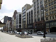
M-1 crosses that district and runs next to the historic Highland Park Ford Plant,[7][9] home of the original moving assembly line used to produce Model Ts;[15][16] opened in 1910, the plant's assembly line dropped the time needed to build a car from 12 hours to 93 minutes and allowed Ford to meet demand for the car.
Between McNichols and 7 Mile Road, Woodward Avenue travels to the east of the Detroit Golf Club in the Palmer Park area.
North of 7 Mile, the highway runs to the west of the Michigan State Fairgrounds and to the east of the Palmer Woods Historic District.
The northern edge of the fairgrounds is at M-102 (8 Mile Road), which is also where Woodward Avenue exits Detroit for the second time; the two boulevards cross in a large interchange.
[7][9] Crossing the border into the suburb of Ferndale in Oakland County, the highway runs through residential neighborhoods but is lined with adjacent businesses.
North of 11 Mile Road, Woodward Avenue forms the border between Berkley to the west and Royal Oak to the east.
The highway passes the Roseland Park Cemetery north of 12 Mile Road before crossing fully into Royal Oak.
That suburb's downtown is centered on the intersection with Long Lake Road; Woodward passes between a pair of golf courses north of there.
[7][9] Many historical sites are located along Woodward Avenue, which was included in the MotorCities National Heritage Area when it was created on November 6, 1998.
[24] In announcing the byway status in 2002, Norman Mineta, then United States Secretary of Transportation, said that "Woodward Avenue put the world on wheels, and America's automobile heritage is represented along this corridor.
The $150,000 glass and concrete sculptures are being placed in the median along Woodward Avenue to serve as landmarks along the route of the roadway and to brand it for tourists.
[8] Nightclubs along Woodward hosted a burgeoning music scene in the early days of rock 'n roll,[34] and the area also had plenty of bars and burlesque shows as late as the 1970s.
One local journalist called the mix of churches, clubs, and bars along Woodward Avenue "a precarious balance between the sacred and the profane".
The district is the most compact collection in any American city, according to Patrick Rishe, the director of the Sports Business Program at Washington University in St.
The first 12,000 Model Ts were built there,[41] before Ford moved production of his cars to the Highland Park plant adjacent to Woodward Avenue in 1910.
[43] During the 1950s and 1960s, automobile engineers street tested their cars along Woodward Avenue between 8 Mile and Square Lake roads; the roadway was the only such location where this activity was practiced.
[52] The wide avenues, in emulation of the street plan for Washington, DC, were intended to make Detroit look like the "Paris of the West".
[57] The first automobile in Detroit was driven by Charles Brady King along Woodward Avenue on March 3, 1896, a few weeks before Henry Ford drove his first car in the city.
[62] Later that year, the Dixie Highway was extended through Detroit to the Straits of Mackinac,[63] following the route of the old Saginaw Trail northward along Woodward Avenue.
[2] John W. Chandler, general manager of the Woodward Avenue Improvement Association,[69] pledged not to shave his face until he had the necessary permissions in hand.
Several buildings were removed to clear the wider street path, and St. John's Episcopal Church was moved 60 feet (18 m) to avoid demolition.
[80][81] A massive address renumbering project ensued along Woodward Avenue in 1997, creating a consistent numbering system from downtown Detroit to Pontiac.
[82] In June 2017, the southernmost block of Woodward Avenue south of Larned Street closed to automobiles to create a temporary pedestrian plaza.
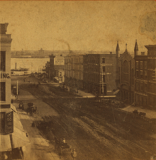
[84] On August 27, 1863, the Detroit City Railway Company (DCRC) established streetcar service along Woodward from Jefferson to Adams avenues.
[88][d] Following the change in control, the city also formed the Detroit Rapid Transit Commission to build a subway system.
Unlike the streetcar conspiracy alleged in other cities, the decline of Detroit's publicly owned system was related to a multitude of different factors.
[91] On April 8, 1956, a parade was held when the last streetcars stopped running along Woodward Avenue and in Detroit;[92] the remaining cars were sent to Mexico City.
[94] Suggestions to unify the two plans were made in late 2008,[95] and the Detroit City Council approved the sale of $125 million in bonds on April 11, 2011, for the longer system.