Interstate 4
After passing near the eastern suburbs of Hillsborough County—including Brandon and Plant City—it enters Polk County, where I-4 crosses along the north side of Lakeland.
Between SR 33 (at exit 38) and US 27, I-4 passes through the fog-prone Green Swamp, although the landscape beside the highway is mostly forest as opposed to water-logged swampland.
Ten variable-message signs and dozens of cameras and vehicle detection systems monitor this stretch of mostly-rural highway as a result of several large, deadly pileups caused by dense fog.
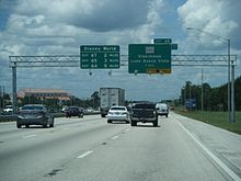
It enters Orange County, passes through Walt Disney World and by SeaWorld Orlando and Universal Orlando, and intersects all of the area's major toll roads, including the Beachline Expressway (SR 528), Florida's Turnpike, and the East–West Expressway (SR 408).
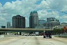
Between Michigan Street and Kaley Avenue (about mile 81), I-4 turns due north (while still being signed east–west), heading past Downtown Orlando and its northern suburbs.
This project replaced most bridges, changed the configurations of many intersections, and added two express toll lanes—named I-4 Express—in each direction.
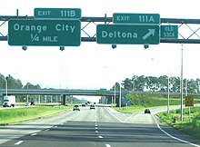
[8][9] After passing along the west side of Downtown Orlando, I-4 continues through the city's northern suburbs—including Winter Park, Maitland, Altamonte Springs, and Sanford.
The Seminole Expressway (SR 417), after passing around the east side of Greater Orlando, has its northern terminus (exit 101B) at I-4 in Sanford.
[13][14][15] FDOT closed a pair of rest areas at the Daryl Carter Parkway overpass (mile 70) near Lake Buena Vista in early 1999 and replaced them with retention ponds to serve runoff from an additional lane in each direction of I-4.
By early 1960, the Howard Frankland Bridge was opened to traffic, as well as the segment from the Hillsborough Avenue/US 301 junction in Tampa to Plant City.
The original western terminus was set at Central Avenue (County Road 150 [CR 150]) in St. Petersburg,[20] though a non-Interstate extension would have continued south and west to Pasadena.
[citation needed] Proposed I-4 was later extended southwest to the present location of I-275 exit 20, with a planned temporary end at US 19 and 13th Avenue South,[21] and a continuation to the Sunshine Skyway Bridge was also designated as part of I-4.
The entire Interstate Highway was completed by the late 1960s; however, the western terminus was truncated to Malfunction Junction in 1971 when I-75 was extended over the Howard Frankland Bridge.
[25] In 2010, the East Central Florida Regional Planning Council (ECFRPC), using geographic information system technology, performed an analysis to determine if this identified zone had an increased fatality rate related to crashes.
The pileup was caused by an unexpected thick morning fog that was mixed with a scheduled—and approved—environmental burn by the Florida Fish and Wildlife Conservation Commission.
The new alignment includes a right-lane ramp exit/entry at the 22nd Street/21st Street Interchange (the previous left-lane configuration was causing hazardous conditions to commuters since its opening in 2005).
As Orlando grew in the 1970s and 1980s, traffic became a growing concern, especially after the construction of the original interchange with the East–West Expressway in 1973, which proved to become a principal bottleneck.
The term "highway hostages" was coined in the 1980s to describe people stuck in long commutes to and from Orlando on I-4.
During the early 2000s, tolled express lanes were being planned in the Orlando area as a traffic congestion relief technique for rush-hour commuters.
The express lanes were slated to extend from Universal Orlando, east to SR 434 in Longwood, and tolls were to be collected electronically via transponders like SunPass and Central Florida Expressway Authority's E-PASS, with prices dependent on the congestion of the eight mainlanes.
In 2012, a legislative ban on tolls along I-4, which had been in place for seven years, ended, and FDOT began soliciting private enterprises to build and help finance the project in a public–private partnership.
FDOT and I-4 Mobility Partners reached commercial and financial close, and a public–private partnership concession agreement was executed in September 2014.
[56] After seven years of construction, the express lanes opened to traffic the morning of February 26, 2022, and began tolling on March 3, 2022.
[57][58] After spending $255 million dollars, FDOT completed the Wekiva Parkway by building 2.63 miles of expressway between Orange Boulevard and the I-4/SR 417 junction in Sanford.
At the junction with I-275, the initial concept alignment calls for a direct connection between the express toll lanes of both highways.
[74] In 2014, FDOT began a study of the feasibility of extending the SunRail commuter train line to Daytona Beach, primarily focusing on the use of the I-4 median.
The ongoing widening project from SR 44 to I-95 maintains a median wide enough to accommodate a future rail line.
[80] In the 2004 US presidential election in Florida, the I-4 corridor, a commonly used term to refer to the counties in which I-4 runs through and a site of significant population growth, was a focus of political activity within the swing state.
Communities along the I-4 corridor were perceived by both major political parties as having higher proportions of undecided voters as compared to more Republican- or Democratic-leaning portions of the state.
It played an equally key role in the 2008 US presidential election in Florida but, whereas the corridor had voted heavily for George W. Bush in 2004, which helped Bush win the state, in 2008, it swung behind Democratic candidate Barack Obama, helping Obama win Florida.