Hurricane Charley
After moving slowly through the Caribbean, Charley crossed Cuba on Friday, August 13, as a Category 3 hurricane, causing heavy damage and four deaths.
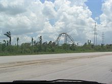
It continued to the north-northeast along the Peace River corridor, devastating Punta Gorda, Port Charlotte, Cleveland, Fort Ogden, Nocatee, Arcadia, Zolfo Springs, Sebring, Lake Placid, and Wauchula.
The city of Winter Park, north of Orlando, also sustained considerable damage since its many old, large oak trees had not experienced high winds.
[3][4] Charley was initially expected to hit further north in Tampa and caught many Floridians off-guard due to the storm turning toward the Florida peninsula sooner than anticipated, within six hours before landfall.
[5] Along its path, Charley caused 10 deaths and $16.9 billion in damage to insured residential property, making it the second costliest hurricane in United States history at the time.
[3][7] Low upper-level wind shear and well-defined outflow contributed to further intensification, and the depression strengthened on August 10, despite being located in the eastern Caribbean, which is an area not particularly suited to tropical cyclogenesis.
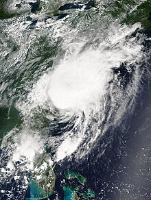
[3] After crossing Cuba near Menelao Mora, Hurricane Charley accelerated to the north-northeast, toward the southwest coast of Florida in response to the approach of an unseasonal mid-tropospheric trough.
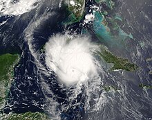
It continued to strengthen as it turned more to the northeast, and made landfall near the island of Cayo Costa, Florida as a 150 mph (240 km/h) Category 4 hurricane with a pressure of 941 mbar (941 hPa; 27.8 inHg) at approximately 1945 UTC on August 13.
[3][4] The extratropical storm continued to move rapidly to the northeast, and was completely absorbed by the front shortly after sunrise on August 15, near southeastern Massachusetts.
[10] Roughly 3,000 passengers from the Carnival Conquest cruise ship were diverted from their scheduled arrival in Montego Bay, resulting in millions of dollars in losses.
Residents along the coast were urged to evacuate by the Office of Disaster Preparedness and Emergency Management due to the risk of storm surge and large swells that could inundate low-lying communities.
Many Floridians remained despite the evacuation order, as authorities estimated that up to a million people would not go to shelters;[25] instead, these residents boarded up their homes and bought supplies to ride out the storm.
National Hurricane Center marine forecaster Robbie Berg publicly blamed the media for misleading residents into believing that a Tampa landfall was inevitable.
Jim Farrell of WINK, Robert Van Winkle WBBH, Steve Jerve of WFLA in Tampa, Jim Reif of WZVN in Fort Myers, and Tom Terry of WFTV in Orlando all broke with their national news forecasts and stated at around 1500 UTC that Charley was going to turn early, striking around Charlotte Harbor and traveling over Orlando, as would prove to be the case.
A hurricane watch was subsequently put into effect for coastal areas from Oregon Inlet to the North Carolina/Virginia border, although by August 15 all advisories were discontinued.
[34] Governor Mike Easley declared a state of emergency in advance of the storm, and 200 National Guard troops were dispatched to Charlotte, Raleigh, Kinston and Lumerton, while 800 more were on standby.
[39] Governor Mark Sanford declared a state of emergency as Charley approached landfall and issued a mandatory evacuation for residents on barrier islands and in coastal locations in counties Georgetown and Horry.
[39] Following the Florida landfall, Georgia Governor Sonny Perdue declared a state of emergency as a precaution against a 4–7 ft (1.2–2.1 m) storm surge and price gouging.
[citation needed] On August 11, a 60 ft (18 m) yacht carrying three people was disabled roughly 58 mi (93 km) southeast of the Morant Cays.
The Jamaica Defence Force Coast Guard rescued the crew members the following day and brought them to Kingston Public Hospital as they were severely dehydrated and exhausted.
[47] The banana industry sustained severe losses, with trees downed and fruit damaged and numerous livestock drowned in flood waters.
[7] The hurricane produced a storm surge of up to 13.1 ft (4.0 m) in Playa Cajio;[3] on the other hand, Charley's quick passage caused small amounts of precipitation, with the largest total being 5.87 inches (149 mm) in Mariel.
[27] However, due to Charley's speed (it crossed the Florida peninsula in approximately seven hours) and small size, rainfall along the eyewall was mostly limited to 4–6 inches (10–15 centimetres).
Furthermore, the storm surge, combined with the strong pressure gradient, produced a 450-metre-wide (0.28 mi) inlet on North Captiva Island,[57] known as Charley's Cut.
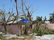
A radio tower near Sebring was toppled, along with numerous trees and power poles along the north and east side of Highlands County.
[61] Throughout the rest of the islands in Sarasota, Charlotte, Lee, and Collier counties, strong winds from Hurricane Charley caused severe damage to hundreds of buildings and trees.
[57] The hurricane dropped generally light rainfall across Florida, with the maximum amount of 9.88 inches (251 mm) occurring in Bud Slough in Manatee County, east of Myakka River State Park.
In Florida, the second-largest producer of oranges in the world, damage to the citrus crop was estimated at $200 million, and caused a 50% increase in the price of grapefruit juice.
[96] As dry air from northern sections of the state wrapped into the circulation of the storm, a band of convection developed along a frontal boundary stretching from Newberry northward.
[102] Tropical Storm Charley produced wind gusts of up to 72 mph (116 km/h) at Chesapeake Light in Virginia, causing scattered power outages.

Tropical storm (39–73 mph, 63–118 km/h)
Category 1 (74–95 mph, 119–153 km/h)
Category 2 (96–110 mph, 154–177 km/h)
Category 3 (111–129 mph, 178–208 km/h)
Category 4 (130–156 mph, 209–251 km/h)
Category 5 (≥157 mph, ≥252 km/h)
Unknown