Hurricane Irma
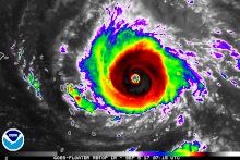
[6] Fluctuations occurred over the next few days due to internal processes, as The first aircraft reconnaissance mission discovered an eye 29 mi (47 km) in diameter and surface winds of 115 mph (185 km/h) on September 3.
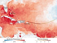
[6] After slowing down late on September 9, the hurricane turned northwestward towards Florida around the southwestern edge of the subtropical high to its northeast and a low-pressure system that was located over the continental United States.
Moving over the warm waters of the Straits of Florida, Irma quickly restrengthened to a Category 4 hurricane at 06:00 UTC on September 10, as deep convection improved and the eye became better defined.
[25] On September 5, the Dominican Republic activated the International Charter on Space and Major Disasters, thus providing for humanitarian satellite coverage;[26] the United States and Haiti followed suit two days later.
While some officials blamed reluctance and indifference on the part of the population, others "admitted they were not prepared for the onslaught and no mandatory evacuation orders were in place ahead of Irma's approach.
Mandatory evacuations were ordered for portions of Brevard, Broward, Citrus, Collier, Dixie, Duval, Flagler, Glades, Hendry, Hernando, Indian River, Lee, Martin, Miami-Dade, Orange, Palm Beach, Pasco, Pinellas, Sarasota, Seminole, St. Lucie, Sumter, and Volusia counties.
Additionally, voluntary evacuation notices were issued for all or parts of Alachua, Baker, Bay, Bradford, Charlotte, Columbia, Desoto, Hardee, Highlands, Hillsborough, Lake, Manatee, Okeechobee, Osceola, and Polk counties.
[51][52] Officials from the Environmental Protection Agency, which had been criticized for its response to Hurricane Harvey, took special measures to inspect and secure hazardous materials, especially at Superfund sites.
[64] Officials in New Orleans stated that there would not be much time for preparations if Irma failed to make the projected northward turn, but that South Texas or Florida would not be a good evacuation destination.
This order also allowed pharmacies to give out 14-day supplies of medicine, and gave women and children from outside the state the ability to participate in the Tennessee Department of Health programs.
[79] Given the rate that current funds are being consumed and the catastrophic damage, the United States Senate almost doubled the requested amount to $15.3 billion, with the understanding that this would only be about 10% of what will be required for responding to Harvey.
[90] The eyewall of the hurricane moved over Barbuda at its record peak intensity early on September 6; a weather station observed a wind gust of 160 mph (260 km/h).
[95] Remaining just outside of Irma's strongest windfield, Antigua sustained less severe damage, in the form of leveled roofs and fences, downed power poles and lines, and uprooted trees.
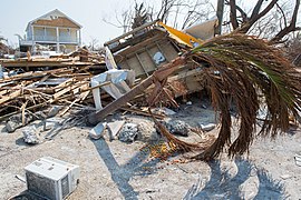
[81] On the morning of September 6, Irma's center crossed the island of Saint Martin while the storm was at peak intensity, sweeping away entire structures, submerging roads and cars, and triggering an island-wide blackout.
[86] A similar situation unfolded in Sint Maarten, Saint Martin's Dutch half, as intense winds ripped through buildings and lifted vehicles aloft "as if they were matches".
[102] The hurricane wreaked havoc on Princess Juliana International Airport, with "huge chunks of the building [strewn] across the runway and a jet bridge snapped in half.
This total covered private property such as homes, vehicles and businesses (including lost revenue); the extent of the damage to infrastructural and public facilities remains undetermined.
[6] Irma struck the state less than two weeks after Potential Tropical Cyclone Ten had caused the worst flooding seen in western Florida in 20 years, which further worsened the impacts in the region.
[189] Along much of the Gulf Coast of Florida, to the north of where Irma made landfall, negative storm surges were observed, with water retracting rather than pushing inland, causing little coastal flooding.
[194] In nearby Clay County, rainfall and storm surge combined to cause extensive flooding along portions of the Black Creek and the St. Johns River, with record high crests at several locations along the former.
[206] In the immediate aftermath of Hurricane Irma's path through the West Indies and Caribbean, the devastation to roads, harbors and airports significantly impeded the transportation and distribution of relief supplies.
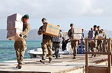
A Miami cargo plane landed on Antigua later that day, carrying over 60 tons (120,000 lbs) of relief supplies for the displaced storm victims—including bottled water, canned food and power generators.
[216] The Prime Minister of the United Kingdom, Theresa May, pledged an additional £25 million worth of funding as part of relief efforts in the region on September 13, 2017, and the Secretary of State for Foreign and Commonwealth Affairs, Boris Johnson, said that a further 250 UK military personnel would be deployed into the area within the next few days.
International freight shipping was projected to be offline for a week, and costs for rebuilding supplies were inflated due to demand in the U.S.[234] Swollen rivers contributed to worsening flooding in the days after the storm system left, resulting in additional evacuations.
United Nations peacekeepers from Brazil were able to gain access to the flooded northwest region to provide urgent aid, but non-governmental organizations and Haitian economists warned that the estimated 30,000 victims would need longer-term assistance as well.
Prime Minister Jack Guy Lafontant appointed a government commission to address Irma's effects, with Action Against Hunger in charge of humanitarian coordination.
[238] On Saint John, described as "perhaps the site of Irma's worst devastation on American soil," it took six days for an active-theater disaster zone to be established, leading to criticism of the U.S. government response.
[209] On both sides of Saint Martin, desperate conditions combined with food and water shortages in Irma's aftermath led to reports of violence, scavenging, and theft.
[246] Sporadic reports of looting and burglaries at several Miami Metro area businesses occurred with the theft of non-essential items such as sports apparel and athletic shoes during the height of the storm.
In the span of two weeks, two Category 4 hurricanes—Harvey and Irma—struck the continental United States, the first time on record two Atlantic tropical cyclones of such strength made landfall on the country in the same hurricane season.

Tropical storm (39–73 mph, 63–118 km/h)
Category 1 (74–95 mph, 119–153 km/h)
Category 2 (96–110 mph, 154–177 km/h)
Category 3 (111–129 mph, 178–208 km/h)
Category 4 (130–156 mph, 209–251 km/h)
Category 5 (≥157 mph, ≥252 km/h)
Unknown