Yan'an Road
The streets were joined together under a common name by the Republic of China government in 1945, then renamed in the early 1950s after the Chinese Communist Party took over Shanghai.
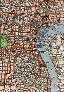
Yangjing Creek (t 洋涇浜, s 洋泾浜, Yángjīng Bāng), also formerly romanized as Yang-ching-pang and Yang-king-pang,[citation needed] was the southern boundary of the British Concession established after the unequal Treaty of Nanjing ended the First Opium War in 1842.
[2] The eastern end of Yan'an Road East features a group of historic skyscrapers dating from the early 20th century.
Further west, the road is today mainly lined with large contemporary skyscrapers, as well as several government office buildings.
The eastern part in 1910 within the western extension of the International Settlement by filling in another canal, the Chaixing Bang.
[2] The east end of Yan'an Road West features a number of historic mansions, such as Kadoorie's House.
Between 1995 and 1997, an elevated expressway was built along Yan'an Road, as the east–west axis of an urban elevated expressway network, beginning in the west at Hongqiao Airport and ending in the east with a left turn down a ramp onto the surface road of the Bund.
The line is operated with trolley buses running on dedicated transit lanes along the surface-level roadway (i.e. under the elevated expressway).