Maidenhead Waterways
The flood plain between Cookham and Windsor has the remains of many old waterways, serving over time as boundaries, drainage channels, mill leats and in parts, for navigation.
Channel clearance work over the last few years by volunteers has removed most of the tree blockages and it is now usable (albeit still with some challenges) by canoes and rowing boats.
In recent years the York Stream channel in the centre of Maidenhead had become narrow, shallow and prone to dry out at times of low flow on the main River Thames that feeds it.
[2] By October 2008, a long-term renewal scheme was in progress, aiming to restore and upgrade the old waterways and allow boats into the centre of Maidenhead.
[9] The York Road development was managed as a joint venture between the Royal Borough and Countryside Partnerships South, who were awarded a contract in April 2017.
These included the production of detailed plans outlining how the waterways would be managed and maintained, and a requirement that the project was completed within five years from the date at which work started.
[12][13] Work on this first stage of the build began in early 2015, with the flow of the York Stream being diverted by a temporary dam down the usually empty Moor Cut channel in February.
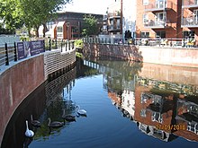
In December 2015 the Royal Borough of Windsor and Maidenhead announced its intention to provide £3 million to fund the next stage of the build, allowing the 0.6-mile (1 km) long York Stream arm of Maidenhead's waterway 'Ring' to be completed, including the construction of a weir with a fish pass and boat rollers at the southern end, to raise the surface water level throughout the town centre.
[12] Shanly Homes contributed to the cost of the waterway build and also built an informal 200 seat waterside amphitheatre for public use next to the Library and a new footbridge over the channel.
[16] Phase 1, including the weir, fish pass and landscaping was completed in March 2020, enabling small boats to use the York Stream half of the ring.
The third phase of their development, Waterside Quarter, was expected to be completed in 2021 together with the final linking section of the York Stream arm of the waterway ’Ring’.
The total cost to this point was £8 million, which has been provided by Windor and Maidenhead Council and section 106 money from the two developers, Shanly and Countryside, who have building projects along the banks of the waterways.
[21] Moor Cut remains quite shallow, except near its southern end where it joins York Stream, but its bed will be lowered as part of the Stage 3 work.
[22] The route of the complete waterway starts at the Thames near Cliveden Reach, running via the White Brook (Widbrook) across Cookham Moor (fed by a small stream known as Fleet Ditch), to the junction with Strand Water.
The reasons for the quality being less than good included the discharge of sewage into the waterways and physical modification of the channel, which present barriers to the movement of fish.