Zamora, Michoacán
Zamora is surrounded by the fertile Tziróndaro Valley which is an important agricultural area that exports large amounts of produce to the United States.
Zamora is of Iberian origins that can be traced to the Latin "Civitas Murata" meaning "The Walled City" because it is surrounded by high hills.
Zamora was awarded city status by the Constituent Congress in 1825, ratifying a decision made on November 21, 1810 by the Mexican War of Independence revolutionary leader Miguel Hidalgo y Costilla.
During the 19th century, Zamora developed into a great cultural and economic center due to high agricultural productivity and flourishing commerce.
Zamora was one of the first cities in the state that implemented new technologies like: railroad stations, telegraphs, telephones, electricity, modern water systems.
The Mexican Revolution reached the state in 1911, when those loyal to Francisco I. Madero proclaimed the city and surrounding area their territory.
After the Mexican Revolution, the Cristero War continued to devastate the region's agriculture which had detrimental economic effects to the city.
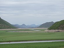
Zamora de Hidalgo is located in the northwestern part of the state of Michoacán on the Tarascan Plateau at an elevation of 1,567 m 5,141 ft) above sea level.
More specifically the city is found in Tziróndaro Valley (Purépecha for "Swamp place"), a large alluvial plain surrounded by mountains with a northeast-southeast orientation.
The dominant basalt rock found in the area give the soil a rich source of: calcium, magnesium, iron, potassium, and sodium.
Universities Zamora has six institutes of higher education: A number of historic buildings dot the city center, built during Spanish colonial times (virreinato) and the 19th century.