Zollernalbkreis
The district is located in the Swabian Alb, and contains the second highest elevation of this range, the 1,011-metre (3,317 ft) high Oberhohenberg.
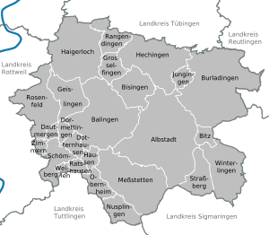
Neighboring districts are (from north clockwise) Tübingen, Reutlingen, Sigmaringen, Tuttlingen, Rottweil and Freudenstadt.
[2] The Pleißne was spoken by hawkers selling items such as baskets, brushes, and whips, and belongs to Rotwelsch.
The meadow at the Dreibannmarke served as a stopping place for traveling merchants, wagons and craftsmen.
After the inauguration of the firing ranges, a meadow in Meßstetten was allocated as a camping site at the edge of the restricted area.
In Frommern a line of high polished industrial production take up the ideas of the royal Hofebenist.
In the Haus der Volkskunstof the Schwäbischer Albverein the traditional Himmelbett is use as a hotel bed.