1893 Atlantic hurricane season
[nb 1] The season is considered hyper-active in terms of accumulated cyclone energy, achieving a total of 231 units, which remains the third-highest ever recorded in the Atlantic basin.
In the absence of modern satellite and other remote-sensing technologies, only storms that affected populated land areas or encountered ships at sea were recorded, so the actual total could be higher.
[2] The first system was initially observed on June 12 in the Bay of Campeche, while the twelfth and final storm transitioned into an extratropical cyclone on November 9 over the northwestern Atlantic.
However, a study by climate researcher Michael Chenoweth, published in 2014, lists thirteen tropical cyclones, proposing the removal of fifth, eleventh, and twelfth systems as well as the addition of four new storms, but his reanalysis has yet to be added to HURDAT.
The most intense tropical cyclone of the season, the tenth system, peaked as a Category 4 hurricane on the present-day Saffir–Simpson scale with maximum sustained winds of 130 mph (215 km/h).
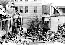
[nb 2] Another very deadly cyclone, the season's sixth system, brought devastating storm surge and high winds to the Sea Islands region of the Southeastern United States and nearby inland areas in late August, killing at least 1,000 people and inflicting damage totaling about $1 million.
[4] However, a more recent reanalysis by climate researcher Michael Chenoweth, published in 2014, adds four storms and removes three others—the fifth, eleventh, and twelfth systems—for a net gain of one cyclone, although these proposed changes have yet to be approved for inclusion to HURDAT.
[6] However, the system then started losing tropical characteristics and transitioned into an extratropical cyclone about 155 mi (250 km) south of Saint Pierre and Miquelon by 00:00 UTC on June 20.
[12] A 2014 renalysis study by climate scientist Michael Chenoweth created a mostly similar path, albeit showing a landfall farther west over Florida and then the storm moving east of North Carolina.
[5] Observations of this storm began as early as July 4 in the southwestern Caribbean Sea,[13] with a ship encountering the cyclone about 130 mi (210 km) north-northeast of Colón, Panama.
Continuing northwestward, the system then re-strengthened slightly, reaching winds of 90 mph (150 km/h) prior to making landfall in northern Belize around 00:00 UTC on July 7.
[5] Based on a reanalysis conducted by meteorologist Ivan Ray Tannehill in 1938,[16] the Atlantic hurricane database begins the track of this storm about 730 mi (1,175 km) east of Trinidad and Tobago on August 13.
That day, the system strengthened into a major Category 3 hurricane with winds of 115 mph (185 km/h),[3] based on the bark Glencoyn observing an atmospheric pressure of 952 mbar (28.1 inHg) early on August 23.
[5] In the Bahamas, significant impacts were reported on the Abaco Islands, particularly at Marsh Harbour, with damage being "very large to houses, wharves, fences, boats, fields and in fact everything", according to The Nassau Guardian.
[42] The National Hurricane Center places the death toll between 1,000–2,000, mostly in the Sea Islands,[43] while the Red Cross estimated that approximately 30,000 survivors in the region became destitute.
[45] The official track for this storm begins on August 20 to the southwest of the Cabo Verde Islands,[3] similar to the paths created by Charles Mitchell in 1924 and C. J. Neumann in 1993.
[5] The official Atlantic hurricane database begins the track for this cyclone on September 4 over the northwestern Caribbean, based on land observations around the Gulf Coast of the United States from the following day.
[3] Heavy rains fell over southern Louisiana, including a peak total of 15.2 in (390 mm) in Franklin, while Donaldsonville, Emilie, and Wallace broke 24-hour precipitation records for the month of September.
The hurricane then turned northeastward and at around 13:00 UTC on October 13, it made landfall near McClellanville, South Carolina, winds of 120 mph (195 km/h) and a barometric pressure of 955 mbar (28.2 inHg).
Moved rapidly northward through North Carolina and the Appalachian Mountains, the cyclone was still a Category 1 hurricane as it passed 60 mi (95 km) west of Washington, D.C.
The storm transitioned into an extratropical cyclone over far southern Quebec on October 14 after crossing Lake Ontario and continued northeastward until dissipating over the northeastern portions of the province on the following day.
[52] In Florida, storm surge reached several feet above ground between Palm Beach and Jacksonville, while heavy rains fell, leading to flooding in a number of coastal communities.
Thereafter, the cyclone brushed Cozumel and then made landfall in Mexico's Yucatán Peninsula near Puerto Morelos as a Category 2 hurricane early on September 29.
While nearing the Gulf Coast of the United States, the system intensified significantly, peaking as a Category 4 hurricane with winds of 130 mph (215 km/h) and a minimum pressure of 948 mbar (28.0 inHg) at 06:00 UTC on October 2.
[5] Strong winds and storm surge left extensive effects in southeastern Louisiana, with towns between New Orleans and Port Eads suffering major damage, especially communities such as Cheniere Caminada and Grand Isle.
[66] Abnormally high tides and storm surge in Alabama caused damage, especially in the Mobile area, with the commerce district submerged with 4 ft (1.2 m) of water.
In Florida, The New York Times noted that "on every street, uprooted trees, broken fences and roofless buildings testify of the storm's force" in Pensacola.
Several other places in the Southeastern United States reported heavy rainfall,[61] while high tides in North Carolina and Virginia capsized a few ships and drowned two people in the former.
[5] A low-pressure area became a tropical storm on November 5,[71] situated about 385 mi (620 km) east of Marsh Harbour in the Bahamas,[3] though Partagás noted the possibility of the system having subtropical characteristics.
On November 8, the cyclone passed within 50 mi (80 km) of the Outer Banks of North Carolina with winds of 70 mph (110 km/h) but curved northeastward and remained offshore.