Tropical cyclone observation
The passage of typhoons, hurricanes, as well as other tropical cyclones have been detected by word of mouth from sailors recently coming to port or by radio transmissions from ships at sea, from sediment deposits in near shore estuaries, to the wiping out of cities near the coastline.
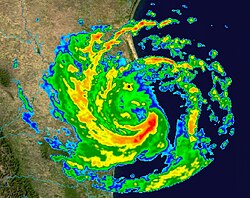
Since World War II, advances in technology have included using planes to survey the ocean basins, satellites to monitor the world's oceans from outer space using a variety of methods, radars to monitor their progress near the coastline, and recently the introduction of unmanned aerial vehicles to penetrate storms.
Recent studies of the 18O and 13C isotopes found in stalagmites in Belize show that tropical cyclone events can leave markers that can be separated out on a week-by-week basis.
By studying the calcium carbonate in coral rock, past sea surface temperature and hurricane information can be revealed.
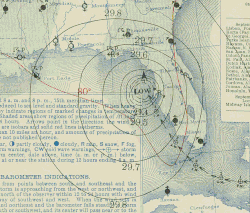
However, the situation changed in the 19th century as seafaring people and land-based researchers, such as Father Viñes in Cuba, came up with systematic methods of reading the sky's appearance or the sea state, which could foretell a tropical cyclone's approach up to a couple days in advance.
Kam-biu Liu et al. (2001) reconstructed a 1,000-year time series of typhoon landfalls in the Guangdong Province of southern China since AD 975 and found that on a decadal timescale, the twenty-year interval from AD 1660 to 1680 is the most active period on record, with twenty-eight to thirty-seven typhoon landfalls per decade.
The variability in typhoon landfalls in Guangdong mimics that observed in other paleoclimatic proxies (e.g., tree rings, ice cores) from China and the northern hemisphere.
[7] As Christopher Landsea et al. point out, many tropical cyclones that formed on the open sea and did not affect any coast usually went undetected prior to satellite observation since the 1970s.
These undercounts roughly take into account the typical size of tropical cyclones, the density of shipping tracks over the Atlantic basin, and the amount of populated coastline.
Combined with ship observations and newspapers, they formed the total information network for hurricane detection until radiosondes were introduced in 1941 and reconnaissance aircraft began in 1944.
The idea of aircraft reconnaissance of tropical cyclones first was put forth by Captain W. L. Farnsworth of the Galveston Commercial Association in the early 1930s.
In 1957, the National Weather Service established the United States' first radar network to cover the coastline and act as first warning of an impending tropical cyclone.
The extent of banding and difference in temperature between the eye and eyewall is used within the technique to assign a maximum sustained wind and pressure.