1925 Tri-State tornado
The tornado immediately began to produce heavy damage to structures before directly impacting Annapolis, destroying ninety percent of the town and killing two people.
Deep ground scouring was observed as the tornado moved past Sedgewickville, and debris from the town was found almost 50 mi (80 km) away.
It would hit several other small communities, including Brazeau and Frohna, before crossing state lines into Southern Illinois and directly impacting Gorham.
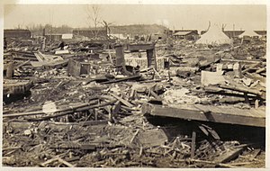
To the northeast, it would hit the northern portions of Murphysboro, where over one hundred residents would die as the tornado barelled through the town at an estimated forward speed of 62 mph (100 km/h).
At the Peabody Mine 18 in Caldwell, a large 80-foot coal tipple weighing several hundred tons was blown over and rolled by the tornado.
Simultaneously, a mid- to upper-level shortwave trough likely approached the northwest coast of the U.S. and moved rapidly through the persistent ridge then digging southeastward across the Great Basin and central Rocky Mountains and emerging in the Plains over Colorado.
A maritime Polar (mP) cold front draped southwestward across eastern Texas with a dry line forming directly to the south of the low.
The open shortwave, likely somewhat negatively tilted, was continuing to approach from the northwest and an apparent outflow boundary moved just to the south of the warm front over northeastern Arkansas and northwestern Tennessee.
Concurrently, a capping inversion likely suppressed storms throughout the warm sector, leaving the Tri-State supercell undisturbed by nearby convection.
A bulge in the dry line may also have been forming slightly south of the low, and southerly to southeasterly surface winds were backing and increasing with time throughout the warm sector.
Around 4:00 p.m. CST (22:00 UTC), the low's central pressure lowered to around 998 hPa (29.5 inHg), centered over south-central Illinois, as the supercell was moving into Indiana.
A very strong low level jet was also in place just above the surface as winds veered with height, resulting in low-level curvature and long hodographs.
Theoretical hodographs returned estimated storm relative environmental helicity (SREH) values of 340 m2 s−2 in the vicinity of the Tri-State supercell track.
[1] The tornado was first sighted as a highly visible and relatively small condensation funnel in the rugged forested hills of Moore Township, Shannon County, Missouri, at about 12:40 p.m. CST.
[4] It then crossed into the sparsely populated areas of Madison County south of Fredericktown, where near Cherokee Pass the tornado steadily began to grow larger.
Multiple homes and farms were completely destroyed near Lixville, where a farmer and three children were killed, and a third child died from her injuries one week after the storm.
The tornado leveled all but the extreme southeastern side of town, where many densely populated working-class neighborhoods saw some of the storm's most horrific effects.
Of those injured, 46 more later died, bringing the storm's death toll at Murphysboro to 234, to date being the highest exacted by a tornado of any single city in the United States.
[19][20]After exiting De Soto, the tornado clipped the northwest corner of Williamson County, narrowly missing the town of Hurst and striking the small village of Bush.
Karnes' wife, a married daughter and her husband, a daughter-in-law and seven grandchildren, ages ranging from newborn to seven years, died in the tornado.
In White County the tornado passed just two miles north of Carmi, missing the towns of Enfield and Crossville by just a few hundred yards.
[6] After exiting Griffin, the tornado made a slight turn towards the northeast as it crossed into Gibson County, devastating rural areas and clipping the northwest corner of Owensville, resulting in nine fatalities.
[29] The tornado traveled more than 10 mi (16 km) to the northeast, crossing into Pike County before finally dissipating at about 4:30 p.m. CST, near Oatsville.
[35] The storm claimed its final victim on January 3, 1926, when Gervais Burgess, a 46-year-old coal miner from West Frankfort, died from injuries sustained in the tornado.
Three states, 14 counties, and more than 19 communities, four of which were effectively effaced (several of these and other rural areas never recovered), were in the path of the tornado, which had lasted a record duration of three and a half hours.
[39] Total damage was estimated at $16.5 million in 1925 dollars; adjusted for increases in population/wealth and inflation, the toll is approximately $1.4 billion (1997 USD), surpassed only by two extremely destructive tornadoes, each of which was posthumously rated F4, both in the City of St. Louis, in 1896 and 1927.
[45] The tornado was frequently described by witnesses as an "amorphous rolling fog" or "boiling clouds on the ground",[46] and fooled normally weather-wise farm owners (in addition to people in general) who did not sense the danger until the storm was upon them.
The parent supercell apparently transitioned to a high-precipitation (HP) variety by the time it struck West Frankfort, meaning that the tornado was not readily visible as it approached, as it was often shrouded in heavy rain and hail.
No single factor accounts for the exceptional path length and duration, though the fast forward motion of the tornado, which averaged 59 mph (95 km/h), may have translated to more distance covered.
However, the 151-to-174-mile-long (243 to 280 km) figures for the path are considered most likely to be continuous solely because observations were sufficiently dense, whereas the 219-mile-long (352 km) figure from westernmost Reynolds County, Missouri, to westernmost Pike County, Indiana, contained several gaps in which eyewitnesses and reports of damage were lacking, owing primarily to sparse patterns of human settlement, but this may well have been continuous because the alignment of reports showed a consistent heading, suggestive of a single tornado rather than a family.