1929 Bahamas hurricane
Parts of the island were inundated by a 12 ft (3.7 m) surge that advanced 20 mi (32 km) inland, wiping out all crops and most fruit trees and livestock.
The economic downturn was further compounded by a sharp reduction in demand in the colony's sisal and sponge after World War I, a weak Pound sterling relative to the American dollar, and a severe drought in the central and southern islands.
[5] Hurricane warning systems in the Bahamas were mostly non-existent in 1929; islanders relied on personal weather instruments or the behavior of clouds, tides, and fauna to assess risk.
[7][8] The hurricane can be traced back to a complex of disturbed weather near Cabo Verde on September 11, producing showers across the open waters of the Atlantic and directed westward by the Azores High.
[10] A portion of this trough split off and moved northwest towards the South Atlantic states while the remaining disturbance continued to organize,[9] becoming a tropical depression approximately 355 mi (570 km) northeast of San Juan, Puerto Rico, by September 18.
[10] On September 25, the steamship Potomac measured a central air pressure of 924 mbar (hPa; 27.30 inHg), suggesting wind speeds of 155 mph (250 km/h): a high-end Category 4 hurricane on the Saffir–Simpson scale.
[10] At 00:30 UTC on September 25,[13] the intense hurricane passed over Nassau with sustained winds of 145 mph (230 km/h);[10] the capital city was within the calm of the eye for two hours.
[11] On September 30, the storm made an unexpectedly sharp turn towards the northeast,[9] making landfall near Panama City, Florida, near midnight as a low-end hurricane with winds of 80 mph (130 km/h).
[10][17] Positioned near a steep temperature gradient, the storm quickly transitioned into an extratropical cyclone on October 1 shortly after landfall with cold air wrapping around the circulation.
[8] The steamship Wisconsin Bridge went aground along the southeastern tip of Abaco Island near the Hole-in-the-Wall lighthouse;[27] all but one of the 34 crew chose not to evacuate, and those that did perished.
[28] As the storm's center progressed from the Tongue of the Ocean towards the west of the Bahamas, Andros Island endured hurricane-force winds and rough seas for nearly 48 hours.
Seventy sought refuge at a Wesleyan mission house only for the building to be inundated by water, forcing the evacuees to relocate to the local schoolhouse.
[39] Few homes were left unscathed, with damage to private property "enormous" according to an Associated Press report and meteorologist Ivan Ray Tannehill.
[8][39] Nassau was also inundated by the storm surge and heavy rainfall, submerging parts of the city's southern district with over 4 ft (1.2 m) of water for several days.
[8] The House of Assembly of The Bahamas held a special session between October 16–24, 1929, authorizing relief funds for the islands after assessing the damage and reconstruction needs.
[8] The Bahamas Parliament passed The Poor People's Housing Hurricane Act of 1929, creating a hire purchase system through which the colonial government could lend £6,000 to individual tenants.
Relief efforts were organized by various groups, including the Bahamas Humane Society, Daughters of the Empire, Infant Welfare Association, and Wesleyan Methodist Missionary School.
Compliance with these codes was intended to secure buildings against winds up to 185 mph (300 km/h), mandating hurricane straps, tar paper, and vertical columns of steel-reinforced concrete on new construction.
Weather Bureau forecasters were forced to frequently change the scope of their warnings due to the hurricane's slow movement, unusual southwesterly track, and lack of observations in the region.
[53] A partial evacuation of the Everglades was conducted on September 25; several hundred people sought refuge in West Palm Beach while others fled to Arcadia and Sebring.
[52] An emergency organization chaired by the American Red Cross and made of several committees was convened at the Comeau Building in West Palm Beach.
[52] Six hundred members of the American Legion around West Palm Beach were directed to convene and aid in emergency efforts under the supervision of the Red Cross.
[63][64] The Red Cross designated the lobby of a hotel in West Palm Beach as an emergency hospital to process all medical and surgical cases during the storm.
[66] With the storm's threat now magnified farther south, the United States Coast Guard cutter Tallapoosa was dispatched to Key West to render aid to ships in the area.
The resulting damage was "remarkably small for a storm of this character" according to the Weather Bureau, with the state incurring $676,000 in losses; other accounts estimated $821,000,[14] while a figure of $1 million was published in the Bulletin of the American Meteorological Society.
[14] In Key West, small fishing boats in the upper harbor were overtaken by the high seas, and lighting and telephone service was disrupted; losses were estimated at a few thousand dollars.
[78] However, losses sustained by fruit crops in Dade County were ultimately greater, reaching $1.5 million according to monthly records maintained by the National Centers for Environmental Information.
[79] The tornado lifted within a minute of touching down and produced the severest impacts from the hurricane in Fort Lauderdale,[80] inflicting $100,000 in damage and injuring 16 people,[27][81] most of whom it flayed with airborne glass.
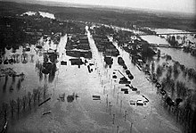
[85] The first part of this heavy rainfall event was attributed to a convergence zone that remained over the southeastern U.S. from September 23–28, repeatedly drawing moisture from the hurricane.
[88] In Maine, heavy rains up to 1.88 inches (48 mm) flooded storm cellars and broke a prolonged dry spell in the state, though damage was minimal.

Tropical storm (39–73 mph, 63–118 km/h)
Category 1 (74–95 mph, 119–153 km/h)
Category 2 (96–110 mph, 154–177 km/h)
Category 3 (111–129 mph, 178–208 km/h)
Category 4 (130–156 mph, 209–251 km/h)
Category 5 (≥157 mph, ≥252 km/h)
Unknown