Hurricane Betsy
Hurricane Betsy was an intense, deadly and destructive tropical cyclone that brought widespread damage to areas of Florida and the central United States Gulf Coast in September 1965.
The storm's erratic nature, coupled with its intensity and minimal preparation time contributed to making Betsy the first tropical cyclone in the Atlantic basin to accrue at least $1 billion in damage.
[nb 1] While the storm primarily affected areas of southern Florida and Louisiana, lesser effects were felt in the Bahamas and as far inland in the United States as the Ohio River Valley.
After executing a slight anticyclonic loop north of the Bahamas, Betsy proceeded to move through areas of south Florida on September 8, causing extensive crop damage.
After emerging into the Gulf of Mexico, the cyclone strengthened and reached its peak intensity equivalent to that of a Category 4 hurricane on September 10 before making its final landfall near Grand Isle, Louisiana, shortly thereafter.
The cyclone propelled damaging storm surge into Lake Pontchartrain, breaching levees in New Orleans and inundating several neighborhoods, most notably the lower Ninth Ward.
[1] Under these conditions, Betsy proceeded to quickly intensify,[1] and reconnaissance missions tasked by the United States Air Force[nb 3] and Weather Bureau indicated that the tropical storm had reached hurricane intensity by 0000 UTC on August 30,[2][4] centered roughly 200 mi (320 km) north-northeast of Puerto Rico.
[8] Due to increasing atmospheric pressure heights to the north,[1] Betsy drastically slowed in forward speed and intensification,[2][4] and remained stationary for a period of time on August 31 before it began to drift westward.
[2][4][15] However, on September 5, a blocking ridge of high pressure situated over the Eastern United States forced Betsy to make a tight,[16][17] clockwise loop and track in an unusual southwesterly path, redirecting it towards Florida and The Bahamas.
[1][2][4][19] Early on September 8,[20] Betsy made landfall on Key Largo in extreme southeastern Florida with winds of 125 mph (205 km/h) and a minimum barometric pressure of 953 mbar (hPa; 28.15 inHg).
[1][22] Situated in the warm waters of the Gulf of Mexico on September 8,[21] Betsy began to strengthen and accelerate towards the west and then northwest,[4] under the influence of the same ridge of high pressure that had forced it southwestward three days prior.
At 0000 UTC the next day, Betsy reached its primary peak intensity with winds of 140 mph (220 km/h) and a minimum central pressure of 942 mbar (hPa; 27.79 inHg) shortly before moving ashore a rural area of Louisiana coastline adjacent to Houma and Grand Isle early on September 10.
[31] In the Palm Beach area, a group composed of regional Red Cross disaster chairman Forest W. Dana and nearby town officials held a nearly nonstop radio vigil service.
[35] The United States Weather Bureau urged for the reopening of grocery stores and lumberyards which had been closed for Labor Day in order to increase availability of hurricane preparedness materials to potentially affected populations.
The U.S. Navy abandoned its housing project on Big Pine Key to avoid the hurricane, while sheriff deputies in Marathon, Tavernier, and Islamorada strongly advised evacuation in those respective cities.
[46] Radio services in Havana alerted residents along the shores of Pinar del Río Province of potentially dangerous storm surge, and urged immediate precautionary measures.
[43] Upon the operational development of Betsy into a tropical storm on August 27,[2] the San Juan Weather Bureau Office issued gale warnings for Barbados, St. Vincent and the Grenadines, and Martinique.
[47] As a result of Betsy executing a loop and beginning to tracking southwestward, these watches were never issued, however, the Weather Bureau advised extreme caution in several Bahamian islands, though once again no warnings were specified.
[19] Early on September 6, as Betsy was tracking through the Bahamas,[2] a hurricane watch and gale warning were issued for portions of the Southeastern Floridian coast from Cape Kennedy to Key West.
[1] Offshore, the Dutch freighter Sarah Elizabeth was caught in rough seas and had lost control of its rudder while it was pulled by continuous wave action towards Egg Island.
[1][38][43] The last message received by the Miami Weather Bureau office from communication operators in Nassau during the storm was a report of 80 mph (130 km/h) winds and rough seas late on September 6.
[1] The strong storm surge caused severe beach erosion, mostly to areas south of Clearwater on the state's western coast while Betsy was traversing the Gulf of Mexico.
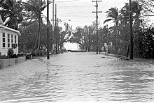
[73] As a result of the waves and wind, three barges were torn out of their moorings, and later drifted downwind before severing a portion of the Rickenbacker Causeway,[76] rendering it impassable and isolating Key Biscayne from the mainland.
In the Miami area, Betsy caused the most severe seawater inundation since a major hurricane struck in 1926;[74] this record was attributed to the highest storm surge reported in as many years.
Betsy also drove a storm surge into Lake Pontchartrain, just north of New Orleans, and the Mississippi River Gulf Outlet, a deep-water shipping channel to the east and south.
Those who did not have family or friends with dry homes had to sleep in the shelters at night and forage for supplies during the day, while waiting for the federal government to provide emergency relief in the form of trailers.
Chlorine gas, which was used frequently as a chemical weapon in World War I, is a powerful irritant that can inflict damage to the eyes, nose, throat and lungs, and (at high concentrations and prolonged exposure) cause death by asphyxiation.
[1] In its early formative stages, Betsy forced the shortening of NASA's Gemini 5 mission by one orbit due to the tropical storm's forecasted track over the initial target splashdown zone near Grand Turk Island.
[98][99] As a result, the spacecraft, which had been orbiting the Earth since August 1965, had its target splashdown zone shifted northward to an area of the Atlantic Ocean well east of Jacksonville, Florida, away from the storm's projected path.
[73] Though no deaths were directly associated with Betsy's effects, a car lost control during a rainstorm in Gallatin County and subsequently crashed; the two occupants later went missing and were presumed dead.

Tropical storm (39–73 mph, 63–118 km/h)
Category 1 (74–95 mph, 119–153 km/h)
Category 2 (96–110 mph, 154–177 km/h)
Category 3 (111–129 mph, 178–208 km/h)
Category 4 (130–156 mph, 209–251 km/h)
Category 5 (≥157 mph, ≥252 km/h)
Unknown


