1973 Atlantic hurricane season
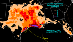
Then, early in September, Tropical Storm Delia hit the northwestern Gulf of Mexico coast, inundating parts of Texas and Louisiana with significant rainfall, which resulted in 5 fatalities and $6 million (1973 USD) in damage.
By the end of July, two more non-developing depressions formed and the first subtropical cyclone, given the name Alfa, developed off the east coast of the United States.
Peaking just below Category 2 status on the newly introduced Saffir–Simpson hurricane scale, Brenda made the first recorded landfall in the Mexican State of Campeche.
[2] On July 4, the storm reached its peak intensity with winds of 90 mph (150 km/h) and a barometric pressure of 986 mbar (hPa; 29.12 inHg), as the eastern portion of the eyewall brushed Bermuda.
[8] During late July, an upper-level low, with a non-tropical cold core, formed near Cape Hatteras, North Carolina and tracked southward.
After moving inland, a strong ridge of high pressure over Texas forced the storm to take an unusual track, eventually leading it to enter the Bay of Campeche on August 20.
The next day, a well-defined eye had developed and the storm attained its peak intensity as a high-end Category 1 hurricane with winds of 90 mph (150 km/h) and a minimum pressure of 977 mbar (hPa; 28.85 inHg).
The storm made landfall later that day near Ciudad del Carmen, Mexico at this intensity, becoming the first hurricane on record to strike the region.
[2] Following the damage wrought by Brenda, a large earthquake struck the region, hampering relief efforts and collapsing numerous structures.
[3] Despite the lack of aircraft reconnaissance in the region, the intensity was determined by wind readings from a German cargo ship that passed through the storm.
Three days later, Christine attained its peak intensity just below hurricane-status with winds of 70 mph (110 km/h) and a minimum pressure of 996 mbar (hPa; 29.41 inHg).
[2] Schools were closed ahead of the storm in Puerto Rico and the United States Virgin Islands as a precaution following the issuance of flood warnings.
A complex steering pattern began to take place later on that day, resulting in the creation of a more hostile environment for tropical cyclones in the Gulf of Mexico.
[2] On September 6, a tropical depression formed over the northwestern Caribbean Sea within a trough of low pressure extended southeastward from Delia, which was situated over southeast Texas at the time.
[2][19] The strongest storm of the season, Hurricane Ellen, began as a tropical wave that moved off the western coast of Africa on September 13.
On September 18, the storm took a nearly due west track and the system became increasingly organized, with an ill-defined eye becoming present on satellite imagery.
[2] The next day, Ellen intensified into a hurricane before taking a sharp turn to the north-northwest in response to a weak trough moving northeast from the Bahamas.
Despite being at an unusually high latitude for development, the storm underwent a brief period of rapid intensification, strengthening into a Category 3 hurricane on September 23.
[20] Shortly after peaking, Ellen transitioned into an extratropical cyclone before merging with a frontal system several hundred miles east of Newfoundland on September 23.
[23] Tracking north-northwestward in response to a break in a subtropical ridge to the north, the depression eventually made landfall near Marineland, Florida and quickly weakened, dissipating before reaching the Gulf of Mexico.
[27][2] By October 4, the system interacted with a mid-tropospheric trough near the southeast United States, resulting in the formation of a surface low.
Satellites monitoring the system depicted a disorganized storm with mainly subtropical characteristics, affected by cooler air from a cold front.
By October 10, Bravo had intensified substantially, as hurricane hunters recorded hurricane-force winds roughly 15 mi (25 km) from the center of the storm.
[3] Shortly after bypassing the Azores islands on October 12, the system moved over an area with sea surface temperatures around 60 °F (16 °C), well below what is required for tropical cyclone development.
Shortly after reaching this intensity, the hurricane transitioned into an extratropical cyclone and quickly merged with a cold front off the coast of France.
[33] On October 12, a French ship encountered the storm, recording sustained winds of 40 mph (65 km/h) and an air pressure of 981 mbar (hPa; 28.97 inHg).
[34] Ships near the English and French coastlines recorded winds up to 60 mph (95 km/h) as the extratropical remnants of Fran passed through the region.
The extratropical remnants of the storm produced hurricane-force wind gusts over parts of Atlantic Canada, peaking at 75 mph (120 km/h); however, no damage was reported.
[2] Roughly a week into the official hurricane season, the fifth depression of the year formed just offshore southeast Florida, near Miami.
A strong depression, it neared tropical storm strength just prior to making landfall in northern Costa Rica on November 18; the system dissipated later that day over land.