1977 Andhra Pradesh cyclone
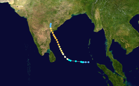
The origins of the 1977 Andhra Pradesh cyclone can be traced to a weak tropical disturbance which was first noted on satellite imagery on the morning of 14 November while located roughly 520 km (320 mi) southwest of the Nicobar Islands.
[nb 1][2] Traveling due west at 25 km/h (16 mph) along the southern periphery of the mid-tropospheric subtropical ridge, the disturbance steadily organized, with increased banding noted on satellite imagery.
This increase in organization prompted the India Meteorological Department (IMD) to report that the disturbance had intensified into a deep depression later that morning,[nb 2][4] and the Joint Typhoon Warning Center (JTWC) to issue a Tropical Cyclone Formation Alert for the system at 13:10 UTC that afternoon.
[nb 3] At 08:00 UTC on 15 November, the JTWC issued its first advisory on the system as satellite data indicated that the storm had continued to strengthen, with estimated one-minute sustained wind speeds of 75 km/h (47 mph).
Early on 16 November, the system intensified into a Category 1-equivalent tropical cyclone on the Saffir-Simpson Hurricane Scale; an eye was observed on satellite imagery later that morning.
[6][7] The next evening, the JTWC estimated that the system had attained its peak intensity as a Category 3-equivalent tropical cyclone, with one-minute sustained winds of 205 km/h (127 mph), while located roughly 140 km (87 mi) off the coast of Andhra Pradesh.
The storm made landfall near Chirala, in the Prakasam district of central Andhra Pradesh, around 11:00 UTC on 19 November with one-minute sustained winds of 195 km/h (121 mph).
Members of the Janata party, an opposing political group to the state government in place at the time, claimed that the cover up was to hide criminal negligence which resulted in tens of thousands of fatalities.
Tropical storm (39–73 mph, 63–118 km/h)
Category 1 (74–95 mph, 119–153 km/h)
Category 2 (96–110 mph, 154–177 km/h)
Category 3 (111–129 mph, 178–208 km/h)
Category 4 (130–156 mph, 209–251 km/h)
Category 5 (≥157 mph, ≥252 km/h)
Unknown
