2011 Tōhoku earthquake and tsunami
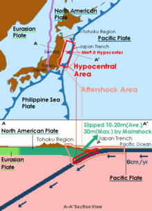
On 11 March 2011, at 14:46:24 JST (05:46:24 UTC), a Mw 9.0–9.1 undersea megathrust earthquake occurred in the Pacific Ocean, 72 km (45 mi) east of the Oshika Peninsula of the Tōhoku region.
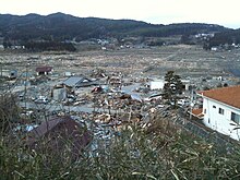
[34][35][36] The earthquake triggered powerful tsunami waves that may have reached heights of up to 40.5 meters (133 ft) in Miyako in Tōhoku's Iwate Prefecture,[37][38] and which, in the Sendai area, traveled at 700 km/h (435 mph)[39] and up to 10 km (6 mi) inland.
[107] The first sign international researchers had that the earthquake caused such a dramatic change in the Earth's rotation came from the United States Geological Survey which monitors Global Positioning Satellite (GPS) stations across the world.
Calculations at NASA's Jet Propulsion Laboratory determined that the Earth's rotation was changed by the earthquake to the point where the days are now 1.8 microseconds shorter.
[121][122] The Geospatial Information Authority of Japan reported land subsidence based on the height of triangulation stations in the area measured by GPS as compared to their previous values from 14 April 2011.
Such discrepancies in the warning were attributed by the JMA to the system's inability to distinguish between two different earthquakes that happened at around same time, as well as to the reduced number of reporting seismometers due to power outages and connection failures.
[148][149] The impact of the tsunami in and around Sendai Airport was filmed by an NHK News helicopter, showing a number of vehicles on local roads trying to escape the approaching wave and being engulfed by it.
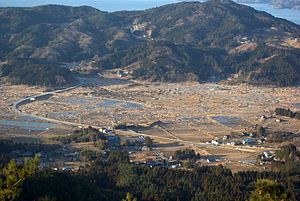
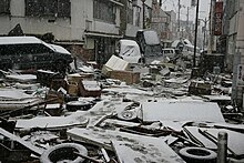
[163][164][165][166][167][168][169] The most severe effects of the tsunami were felt along a 670-kilometer-long (420 mi) stretch of coastline from Erimo, Hokkaido, in the north to Ōarai, Ibaraki, in the south, with most of the destruction in that area occurring in the hour following the earthquake.
[185] A Japanese government study found that 58% of people in coastal areas in Iwate, Miyagi, and Fukushima prefectures heeded tsunami warnings immediately after the quake and headed for higher ground.
Furthermore, shortly after the earthquake, some wave meters reported a fluctuation of "20 centimeters (7.9 in)", and this value was broadcast throughout the mass media and the warning system, which caused some residents to underestimate the danger of their situation and even delayed or suspended their evacuation.
In the updated system, for a powerful earthquake that is capable of causing the JMA magnitude scale to saturate, no quantitative prediction will be released in the initial warning; instead, there will be words that describe the situation's emergency.
There are plans to install new teleseismometers with the ability to measure larger earthquakes, which would allow the calculation of a quake's moment magnitude scale in a timely manner.
[198] Authorities in Wewak, East Sepik, Papua New Guinea evacuated 100 patients from the city's Boram Hospital before it was hit by waves, causing an estimated US$4 million in damage.
[201] Some other South Pacific countries, including Tonga and New Zealand, and US territories American Samoa and Guam, experienced larger-than-normal waves, but did not report any major damage.
[215][216] On the day of the earthquake, the waters of several fjords across Norway appeared to seethe as if boiling, and formed waves that rolled onto shores, most prominently in Sognefjorden, where the phenomenon was caught on film.
[219] Injuries related to nuclear exposure or the discharge of radioactive water in Fukushima are difficult to trace as 60% of the 20,000 workers on-site declined to participate in state-sponsored free health checks.
[238] Among them were two English teachers from the United States affiliated with the Japan Exchange and Teaching Program;[239] a Canadian missionary in Shiogama;[240] and citizens of China, North and South Korea, Taiwan, Pakistan and the Philippines.
By 9:30 UTC on 11 March 2011, Google Person Finder, which was previously used in the Haitian, Chilean, and Christchurch, New Zealand earthquakes, was collecting information about survivors and their locations.
[246] Governments and the military were forced to bury many bodies in hastily dug mass graves with rudimentary or no rites, although relatives of the deceased were promised that they would be cremated later.
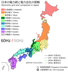
[294] To help alleviate the shortage, three steel manufacturers in the Kanto region contributed electricity produced by their in-house conventional power stations to TEPCO for distribution to the general public.
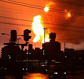
[322] Japan declared a state of emergency following the failure of the cooling system at the Fukushima Daiichi Nuclear Power Plant, resulting in the evacuation of nearby residents.
[336] In 2021, the Japanese cabinet finally approved the dumping of radioactive water in Fukushima into the Pacific Ocean over a course of 30 years, with full support of IAEA.
[364] The rolling blackouts brought on by the crises at the nuclear power plants in Fukushima had a profound effect on the rail networks around Tokyo starting on 14 March.
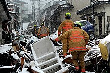
However, the earthquake destroyed town halls (the seat of local municipal government), police, and fire services in many places, so the military not only had to respond to but also command rescues.
[384] There was no damage to the Historic Monuments and Sites of Hiraizumi in Iwate Prefecture, and the recommendation for their inscription on the UNESCO World Heritage List in June was seized upon as a symbol of international recognition and recovery.
The economic impact included immediate problems, with industrial production suspended in many factories, and the longer term issue of the cost of rebuilding, which has been estimated at ¥10 trillion ($122 billion).
[388] In February 2016, a memorial was inaugurated by two architects for the victims of the disaster, consisting of a 6.5-square-metre (70 sq ft) structure on a hillside between a temple and a cherry tree in Ishinomaki.
[393][394] The quake gave scientists the opportunity to collect a large amount of data to model the seismic events that took place in great detail.
[396] Researchers have also analysed the economic effects of this earthquake and have developed models of the nationwide propagation via interfirm supply networks of the shock that originated in the Tōhoku region.
The rarity and magnitude of the earthquake-tsunami prompted researchers Jotaro Urabe, Takao Suzuki, Tatsuki Nishita, and Wataru Makino to study their immediate ecological impacts on intertidal flat communities at Sendai Bay and the Sanriku Ria coast.