2024 Elkhorn–Blair tornado
The tornado reached peak intensity in the neighborhood of Elkhorn and south of the city of Blair, leading the National Weather Service in Omaha, Nebraska to assign a rating of low-end EF4 on the Enhanced Fujita scale, with maximum wind speeds estimated at 170 mph (270 km/h).
[3] The tornado touched down at south of West Q Road near the Platte River and traveled northeastward, damaging trees and farmstead outbuildings.
The tornado then damaged the Heritage Nursery Landscaping business before moving into the Ramblewood subdivision, where it was approximately 0.7 mi (1.1 km) in width.
Initially rated as a high-end EF3 with wind speeds estimated at 165 mph (266 km/h), post-analysis revealed that the tornado was slightly stronger, and was thus upgraded to a low-end EF4 in July 2024.
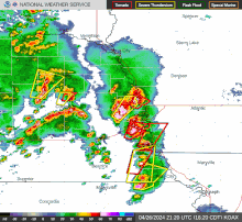
[6] With an enhanced risk of severe weather in place, the Storm Prediction issued a tornado watch for eastern Oklahoma on the morning of April 26.
The tornado was rated as a high-end EF3 on the Enhanced Fujita scale, with wind speeds estimated at 158 mph (254 km/h), reaching a peak width of 700 yards (640 m) along a 8.55-mile (13.76 km) path, remaining on the ground for 12 minutes.
[9] The tornado first touched down at 3:30 pm CDT south of West Q Road near the Platte River and traveled northeastward, damaging trees and farmstead outbuildings at EF0-EF1 intensity.
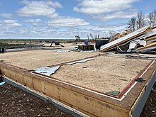
In the initial final report on the tornado released in mid-July 2024, this damage was rated high-end EF3 with winds of 160 mph (260 km/h) due to the walls of the structure not being particularly well-anchored.
However, a reanalysis of this location later in the month revealed that a substantial portion of the home had been swept away and nearby trees were snapped with some debarking noted.
[10] The tornado then damaged the Heritage Nursery Landscaping business before moving into the Ramblewood subdivision, where it was approximately 0.7 mi (1.1 km) in width.
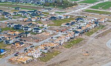
[9][10] The tornado had weakened slightly but remained at high-end EF3 intensity as it struck the subdivision, where it damaged or destroyed numerous homes with winds up to 155 mph (249 km/h).
[9][10] Exiting the subdivision, the tornado grew to almost a mile-wide and crossed N-31, snapped numerous wooden and steel power poles and trees.
[10] The tornado then narrowed to a half-mile wide and weakened to EF1 strength as it continued northeastward, snapping trees and damaging the roofs of outbuildings and homes.
Continuing northeastward, the tornado intensified further to high-end EF2 intensity as it struck a development along Newport Landing Lake to the west of Bennington.
Homes in this area suffered extensive damage with roofs removed and exterior walls knocked down, and power poles and trees were snapped.
After crossing the lake and N-36, the tornado continued to snap trees and power lines and damage outbuildings at EF1 intensity before moving into Washington County.
The tornado then turned east-northeast and dissipated south of Modale at 4:31 pm CDT after being on the ground for 61 minutes, traveling 32.50 mi (52.30 km), and reaching a peak width of 1,900 yd (1,700 m).
This new data suggested that a few small areas of low-end EF4 damage did occur in the Elkhorn tornado, with wind speeds estimated at 170 mph (270 km/h).
[10] The tornado was rated as a low-end EF4 with wind speeds estimated at 170 mph (270 km/h), reaching a peak width of 1,900 yards (1,700 m) along a 32.49-mile (52.29 km) path, remaining on the ground for 61 minutes.

EF1 86–110 mph
EF2 111–135 mph
EF3 136–165 mph
EF4 166–200 mph
⎯ Center of the tornado

EF1 86–110 mph
EF2 111–135 mph
EF3 136–165 mph
EF4 166–200 mph
⎯ Center of the tornado