Aa (France)
The Aa (French pronunciation: [a]; Picard: Abbe) is a river in northern France that is 93 km (58 miles) long.
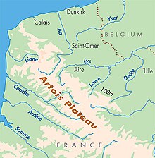
[1][2] Originating near the village of Bourthes and emptying into the North Sea near Gravelines, the Aa is located near the north-eastern limit of the English Channel.
The first segment ranges from the river's source is in the Artois Hills[4] to Saint-Omer to form a small chalk stream, similar to the Somme.
The section of the river from Saint-Omer to the junction with the main Dunkirk-Scheldt waterway and the Canal de Neuffossé are not currently navigable.
The river suffers significant problems from industrial discharge and siltation, which made the length of the Aa from Saint-Omer to the junction with the Dunkirk-Escaut waterway unnavigable since the 1970s.