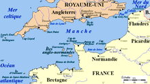
English Channel
By the middle of the fifteenth century, an Italian map based on Ptolemy's description named the sea as Britanicus Oceanus nunc Canalites Anglie (Ocean of the Britons but now English Channel).
Eastwards from there the adjoining North Sea reduces to about 26 m (85 ft) across the Broad Fourteens (14 fathoms) where it lies over the southern cusp of the former land bridge between East Anglia and the Low Countries.
The time difference of about six hours between high water at the eastern and western limits of the Channel is indicative of the tidal range being amplified further by resonance.
[16] Amphidromic points are the Bay of Biscay and varying more in precise location in the far south of the North Sea, meaning both those associated eastern coasts repel the tides effectively, leaving the Strait of Dover as every six hours the natural bottleneck short of its consequent gravity-induced repulsion of the southward tide (surge) of the North Sea (equally from the Atlantic).
During this early period, the Channel did not connect to the North Sea,[18] with Britain and Ireland remaining part of continental Europe, linked by an unbroken Weald–Artois anticline, a ridge running between the Dover and Calais regions.
During Pleistocene glacial periods this ridge acted as a natural dam holding back a large freshwater pro-glacial lake in the Doggerland region, now submerged under the North Sea.
[20] It left streamlined islands, longitudinal erosional grooves, and other features characteristic of catastrophic megaflood events, still present on the sea floor and now revealed by high-resolution sonar.
[28] One occurrence was the MSC Napoli, which on 18 January 2007 was beached with nearly 1700 tonnes of dangerous cargo in Lyme Bay, a protected World Heritage Site coastline.
Atlantic oceanic species are more common in the westernmost parts of the channel, particularly to the west of Start Point, Devon, but can sometimes be found further east towards Dorset and the Isle of Wight.
[30] The Channel has in historic times been both an easy entry for seafaring people and a key natural defence, halting invading armies while in conjunction with control of the North Sea allowing Britain to blockade the continent.
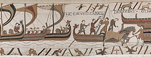
For the next 250 years the Scandinavian raiders of Norway, Sweden, and Denmark dominated the North Sea, raiding monasteries, homes, and towns along the coast and along the rivers that ran inland.
They continued to settle in the British Isles and the continent until around 1050, with some raids recorded along the channel coast of England, including at Wareham, Portland, near Weymouth and along the river Teign in Devon.
The Battle of Trafalgar took place off the coast of Spain against a combined French and Spanish fleet and was won by Admiral Horatio Nelson, ending Napoleon's plans for a cross-Channel invasion and securing British dominance of the seas for over a century.
The exceptional strategic importance of the Channel as a tool for blockading was recognised by the First Sea Lord Admiral Fisher in the years before World War I.
The Dover Patrol, set up just before the war started, escorted cross-Channel troopships and prevented submarines from sailing in the Channel, obliging them to travel to the Atlantic via the much longer route around Scotland.
By February 1915, this had been augmented by a 25 kilometres (16 mi) stretch of light steel netting called the Dover Barrage, which it was hoped would ensnare submerged submarines.
During 1917, the Dover Barrage was re-sited with improved mines and more effective nets, aided by regular patrols by small warships equipped with powerful searchlights.
By a combination of hard fighting and German indecision, the port of Dunkirk was kept open allowing 338,000 Allied troops to be evacuated in Operation Dynamo.
Intense negotiations resulted in some Red Cross humanitarian aid, but there was considerable hunger and privation during the occupation, particularly in the final months, when the population was close to starvation.
[54] Following an accident in January 1971 and a series of disastrous collisions with wreckage in February,[55] the Dover TSS,[56] the world's first radar-controlled traffic separation scheme, was set up by the International Maritime Organization.
[57] In December 2002 the MV Tricolor, carrying £30m of luxury cars, sank 32 km (20 mi) northwest of Dunkirk after collision in fog with the container ship Kariba.
[60] Marine GPS systems allow ships to be preprogrammed to follow navigational channels accurately and automatically, further avoiding risk of running aground, but following the fatal collision between Dutch Aquamarine and Ash in October 2001, Britain's Marine Accident Investigation Branch (MAIB) issued a safety bulletin saying it believed that in these most unusual circumstances GPS use had actually contributed to the collision.
A combination of radar difficulties in monitoring areas near cliffs, a failure of a CCTV system, incorrect operation of the anchor, the inability of the crew to follow standard procedures of using a GPS to provide early warning of the ship dragging the anchor and reluctance to admit the mistake and start the engine led to the MV Willy running aground in Cawsand Bay, Cornwall, in January 2002.
[68] As one of the narrowest and most well-known international waterways lacking dangerous currents, the Channel has been the first objective of numerous innovative sea, air, and human powered crossing technologies.
The steamer was purchased subsequently by the French postal administration and renamed Henri IV and put into regular passenger service a year later.
The journey was undertaken to demonstrate how the Bull Boats of the Mandan Indians of North Dakota could have been copied from coracles introduced by Prince Madog in the 12th century.
[82][83] The Mountbatten class hovercraft (MCH) entered commercial service in August 1968, initially between Dover and Boulogne but later also Ramsgate (Pegwell Bay) to Calais.
[87] On 12 June 1979, the first human-powered aircraft to cross the English Channel was the Gossamer Albatross, built by American aeronautical engineer Dr. Paul B. MacCready's company AeroVironment, and piloted by Bryan Allen.
Up to 1927, fewer than ten swimmers (including the first woman, Gertrude Ederle in 1926) had managed to successfully swim the English Channel, and many dubious claims had been made.
A failed attempt to cross the Channel by two Syrian refugees in October 2014 came to light when their bodies were discovered on the shores of the North Sea in Norway and the Netherlands.