Blue Nile
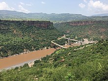
[citation needed] This uncertainty might result from the fact that the river flows through a series of virtually impenetrable gorges cut in the Ethiopian Highlands to a depth of some 1,500 metres (4,900 ft).
[2] The Blue Nile Falls (Amharic: Tis Abay, literally "great smoke"), one of Ethiopia's biggest tourist attractions, is located at the start of the canyon.
Those on the right side, also in downstream order, include the Handassa, Tul, Abaya, Sade, Tammi, Cha, Shita, Suha, Muga, Gulla, Temcha, Bachat, Katlan, Jiba, Chamoga, Weter and the Beles.
During the summer monsoon season, the Blue Nile floods erode a vast amount of fertile soil from the Ethiopian Highlands and carry it downstream as silt, turning the water dark brown or almost black.
These dams also help irrigate the Gezira Scheme, which is most famous for its high-quality cotton, as well as wheat and animal feed crop production in the area.
The source of the Nile proper was also reached in 1629 by the Portuguese Jesuit missionary Jerónimo Lobo and in 1770 by the Scottish explorer James Bruce.
Macmillan encouraged Jenssen to try to sail upstream from Khartoum again in 1905, but he was forced to stop 500 km (300 mi) short of Lake Tana.
In 1968, at the request of Haile Selassie, a team of 60 British and Ethiopian servicemen and scientists made the first full descent of the river from Lake Tana to a point near the Sudanese border led by explorer John Blashford-Snell.
[11] The team used specially-built Avon Inflatables and modified Royal Engineers assault boats to navigate the formidable rapids.
[15] On 28 April 2004, geologist Pasquale Scaturro and his partner, kayaker and documentary filmmaker Gordon Brown, became the first known people to navigate the Blue Nile in its entirety.