Mount Agamenticus
The greater Agamenticus region covers nearly 30,000 acres (12,000 ha) in the southern Maine towns of Eliot, Ogunquit, South Berwick, Wells and York.
[2] Mount Agamenticus is also affectionately known by older locals as "Big A," the nickname of a ski slope that once operated on its northeast flank,[citation needed] remnants of which can be seen both near the summit and along the trails.
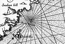
Upon returning to London, Mason presented his record of the New World, complete with aboriginal place names, to Prince Charles, "...humbly entreating his Highnesse hee would please to change their barbarous names for such English, as posteritie might say Prince Charles was their God-father..." He complied, and his choices were featured on the map published in 1616 that accompanied Smith's A Description of New England.
The Agamenticus plantation was personally established from afar by Sir Ferdinando Gorges, whom received an original land charter in 1606.
According to legend, Saint Aspinquid (sometimes Aspenquid) was born in May 1588, and after converting to Christianity, spread the gospel to tribes across the continent.
Mount Agamenticus has the highest elevation of any hill within its distance to the ocean from Portland, Maine, to Brownsville, Texas.