Aguachica
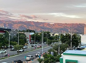
Aguachica (Spanish pronunciation: [aɣwaˈtʃika]), is a city and municipality in the southern region of the Cesar Department, Colombia, located between the inter-Andean valley of Magdalena Medio and the Motilones.
In terms of transportation infrastructure, its geographically strategic position connects the Colombian Caribbean with the Santanderes through the Ruta del Sol, and is also a key communication point for the Catatumbo region via National Route 70.
By 1722 the settlement had grown in the middle of an hacienda predominantly owned by Don Casimiro Ramos de Barahona (also spelled Barahoja).
The settlement was serving now as a rest area for merchants traveling to and from the nearby fluvial port town of Gamarra and Ocaña (present-day Department of North Santander).
[5][4] By this time the Spanish conqueror Jose Fernando de Mier y Guerra was ordered to "pacify" the Chimila indigenous groups and to reorganize some villages in the basin of the Magdalena river.
[6] By 1850 the first migrants arrived to Aguachica largely attracted by the plantations of coffee in neighboring Ocaña, Sovereign State of Santander and also introduced agricultural and farming practices for commerce in the region.
[4] The 1960s were marked by the migration of people from the Department of Tolima mostly farmers interested in exploiting the land, developing large plantations of cotton, sorghum, rice, among other products.
'The Cross Hill') in which religious traditions are practiced[8] and where the pilgrimage of parishioners from the municipality begins,[9] in addition to the San Roque Parish, this building, built in the hacienda of the same name, is considered the starting point of the establishment of the church[10] and history of Aguachica.