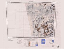
Alatna Valley
An abrupt glacier, 3 nautical miles (5.6 km; 3.5 mi) long, descending into the end of Alatna Valley from the south side of Mount Gunn in the Convoy Range.
An alpine glacier, 1.5 nautical miles (2.8 km; 1.7 mi) long, which flows into Alatna Valley from the south end of Staten Island Heights.
A substantial mountain glacier, 3 nautical miles (5.6 km; 3.5 mi) wide, which flows southward into Alatna Valley, draining both the Staten Island Heights and Mount Razorback areas.
So named by a 1989-90 NZARP field party because strong and persistent winds in this vicinity have cut major flutings through the ice-cliffed terminus of the glacier.
A broad flat glacier filling the bulk of Alatna Valley and having its origin on the slopes of Mount Morrison to the south.
A pond in a moraine enclosed basin at the foot of the cliffs to the south end of Alatna Valley, in the Convoy Range of Victoria Land.
This frozen pond was the site of a 1960-61 USARP field party (Parker Calkin, Roger Hart, and Ellory Schempp) which had to be evacuated in a hurry.