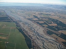
Alluvial plain
In contrast, the alluvial plain is the larger area representing the region over which the floodplains have shifted over geological time.
As the highlands erode due to weathering and water flow, the sediment from the hills is transported to the lower plain.
The leftover higher locations, typically natural levees at the margins of the flood channel, will be eroded by lateral stream erosion, local rainfall, and possibly wind transport if the climate is arid and does not support soil-holding grasses.
These processes, over geologic time, will form the plain, a region with little relief (local changes in elevation) yet with a constant but slight slope.
that form a low gradient, regional ramps along the flanks of mountains and extend great distances from their sources (e.g., High Plains of North America)".