Canterbury Plains
Their northern extremes are at the foot of the Hundalee Hills in the Hurunui District, and in the south they merge into the plains of North Otago beyond the Waitaki River.
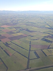
The Canterbury Plains were formed from Quaternary moraine gravels transported from the Southern Alps and deposited here during glacial periods in the late Pleistocene approximately 3 million to 10,000 years ago.
Part of the Canterbury-Otago tussock grasslands, the land is suitable for moderately intensive livestock farming but is prone to droughts, especially when the prevailing wind is from the northwest.
A major earthquake on 4 September 2010 revealed a previously unknown geological fault beneath the Canterbury Plains and created a surface rift that offset features by as much as four metres in places.
Most of the population of Canterbury lives in a series of large and small towns arranged northeast to southwest along the plains, connected by State Highway 1 and the Main South railway line.