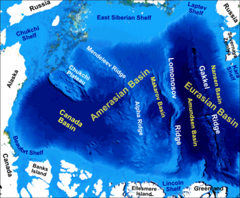
Amerasia Basin
The triangular-shaped Amerasia Basin broadly extends from the Canadian Arctic Islands to the East Siberian Sea, and from Alaska to the Lomonosov Ridge.
The continental shelf around the Amerasia Basin is very broad, averaging up to 342 mi (550 km) in width.
The average depth of the Amerasia Basin is 12,960 ft (3,950 m),[1] and it covers 2,500,000 km2 (970,000 sq mi).
[2] HALIP formation is related to the arrival of a mantle plume, possibly centered on the southern end of the Alpha Ridge.
The plume arrival may have resulted in a regional plate reorganization event, including the opening of the Amerasia Basin and the rotation of the AAC.