Andros, The Bahamas
[citation needed] The modern name is believed to be in honour of Sir Edmund Andros, Commander of His Majesty's Forces in Barbados in 1672 and governor successively of New York, Massachusetts, and New England.
[citation needed] Contemporary records, including official Bahamian census figures from 1788 and 1807, indicate that the number of inhabitants of Andros in that period was fewer than 400, and the original source of this report remains obscure.
Britain gained control following the American Revolutionary War by treaty in 1783, when it exchanged East Florida with Spain for The Bahamas.
Loyalists fleeing the United States during and after the American Revolution settled on various Bahama Islands including Andros, bringing their slaves with them.
In addition, Andros was the destination of many families who were squeezed out of the Belize logwood industry following the relocation of Mosquito Coast settlers to British Honduras in 1787.
[9] After the United States acquired Florida from Spain in 1821, some Seminoles and black American slaves escaped and sailed to the west coast of Andros by the wrecking sloop Steerwater, where they established the settlement of Red Bays.
[10] Hundreds of Black Seminoles and slaves travelling in 1823 by canoe and 27 sloops across the Gulf Stream joined them, with more arriving in later years.
In the 1960s and 1970s The Bahamas, led by Sir Lynden Pindling, the Member of Parliament for Kemps Bay on South Andros, negotiated independence from the British.
[22] Geologically and geographically The Bahamas, including Andros, are not located in the Caribbean, whose northern boundary is the Windward Passage, but rather in the Atlantic Ocean.
The Bahamian dialect of the English language is distinctively Caribbean in character, similar to those of Jamaica and the Cayman Islands, also formerly part of the British West Indies.
Andros lies just north of the Tropic of Cancer, with moderate temperature range affected by its relative proximity to the Gulf Stream to the west.
Notable strikes in the modern era have included Hurricanes Betsy (1965), David (1979), Arlene (1987), Andrew (1992), Lili (1996), Floyd (1999), Michelle (2001), Wilma (2005) and Matthew (2016).
[26] Matthew caused widespread flooding and devastation on the north end of the island around Morgan's Bluff, Lowe Sound, and Nicholl's Town.
[27] A Mennonite mission-run commercial farm was founded near Blanket Sound in 1983, which grows everything from habanero peppers to sorghum and potatoes, and has numerous fruit orchards and honey bee hives.
[28] Androsia, a hand-crafted batik factory founded at Fresh Creek in 1972, produces a vibrant, colourful fabric that has become part of the national dress and identity of The Bahamas.
[29] GreenLife Growers, a Bahamian native tree nursery at Young Sound, provides landscaping material to real estate developers and government projects throughout The Bahamas.
[31] Local handicrafts in the Black Seminole style — particularly wood carvings and woven baskets — are a cottage industry in the settlement of Red Bays.
ANCAT's efforts are closely tied to encouraging eco-tourism, to generate economic incentives to preserve the existing varied habitats of the island.
[34] GreenForce Global Volunteering/Bahamas,[35] an international NGO based in the UK, conducts environmental research from its operation at Stafford Creek on North Andros.
[38] From Nicholls Town in the north to Little Creek in the south are 35–40 hotels, motels, resorts, guest houses and lodges (the number varies), with a total of approximately 400 rooms.
Tourists are composed primarily of scuba divers, attracted to the barrier reef, Tongue of the Ocean, and the Blue Holes; bonefishing anglers, and others looking for relaxation.
[42] Among the various land ecosystems are hardwood coppice, pineyard, scrub, saltwater marsh, rocky and sandy beaches, palm savannas and mangroves.
Nineteen million litres of freshwater are shipped daily to Nassau by barge through the pumping station located in Morgan's Bluff.
[45] The barrier reef and the Tongue of the Ocean, together with mangrove swamps, rocky tidal pools, and estuaries, provide breeding and growing habitats for a wide variety of young marine life.
Andros has a variety of close-to-shore and on-shore ecosystems that may be unique on Earth: tidal inland and ocean blue holes, shallow sand and mud flats, tidal estuaries, mangrove swamps, the pelagic ecozone of the 2,000 m (6,000 ft) drop-off only 1.6 km (1 mi) from shore, the world's third-largest barrier reef, and huge freshwater aquifers.
[46] Most resident bird species of The Bahamas are believed to have come northward from the West Indies, as winds and sea currents favour migration from the south and southeast.
Other birds found on Andros include the loggerhead kingbird, La Sagra's flycatcher, Cuban pewee, Bahama mockingbird, red-legged thrush, thick-billed vireo, black-whiskered vireo, olive-capped warbler, Greater Antillean bullfinch, black-faced grassquit, melodious grassquit, least grebe, olivaceous cormorant, American flamingo, Bahama pintail, osprey, American kestrel, sooty tern, roseate tern, noddy tern, white-crowned pigeon, zenaida dove, Caribbean dove, smooth-billed ani and Cuban emerald hummingbird.
A man from Oregon believes that the legend of the Chickcharney is based on the prehistoric barn owl Tyto pollens, although remains have never been found on Andros and the youngest fossil bones are from a layer before the arrival of the first humans, the Lucayans.
[58] National Geographic magazine has featured the Andros Blue Holes several times over the past thirty years, most recently in August 2010.
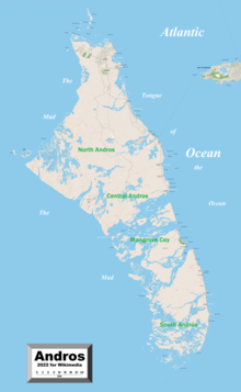
There is one settlement on the west coast, Red Bays, historically settled by American fugitive slaves and Black Seminoles, located at the island's northwestern tip.

Green: 0-15 ft (0.0-4.6 m)
Yellow: 15–30 ft (4.6–9.1 m)
Red: 30–45 ft (9.1–13.7 m)
Violet: 45–60 ft (14–18 m)
Dark blue: 60+ ft (18.3+ m)

