AquaMaps
[3] According to the AquaMaps website in August 2013, the project held standardized distribution maps for over 17,300 species of fishes, marine mammals and invertebrates.
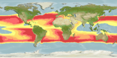
There is also the facility to create custom maps for any species via the web by modifying the input parameters and re-running the map generating algorithm in real time, and a variety of other tools including the investigation of effects of climate change on species distributions (see relevant section of the AquaMaps search page).
The project is coordinated by Dr Rainer Froese of IFM-GEOMAR and involves contributions from other research institutes including the Evolutionary Biology and Ecology Lab, Albert-Ludwigs-University Freiburg, University of British Columbia (UBC), the Swedish Museum of Natural History (NRM - Naturhistoriska Riksmuseet), the WorldFish Center in Malaysia, and CSIRO Marine and Atmospheric Research in Australia.
The creation of AquaMaps is supported by MARA, Pew Fellows Program in Marine Conservation, INCOFISH, Sea Around Us Project, Biogeoinformatics of Hexacorals, FishBase and SeaLifeBase.
A multi-author study by E. Sala et al. utilizing Aquamaps modelled data for marine fishes and invertebrates, entitled "Protecting the global ocean for biodiversity, food and climate", was published in the prestigious journal Nature in 2021.