Archaeology of Samoa
[2] An important part of archaeology in Samoa and Oceania involves finding the answer to the origins of Polynesians,[3] ongoing research which is being undertaken in conjunction with other fields including linguistics and genetics.
The oldest date so far from pre-historic remains in Samoa has been calculated by New Zealand scientists to a likely true age of circa 3,000 BP (Before Present) from a Lapita site at Mulifanua during the 1970s.
Golson also carried out field work on Upolu where he discovered the first pottery sherds in Samoa at Vailele village on the island's north coast.
During 1963-1964, this work was carried out by an international team led by Roger Curtis Green under the Polynesian Archaeology Programme of Auckland University.
Another team leader was New Zealand archaeologist Janet Davidson who has made major contributions to the field of archaeology in Samoa and the rest of the Pacific.
However, a key finding near the end of this trip was the discovery of Lapita pottery remains at Mulifanua with radio carbon dates of 930-800 BC.
Extensive pre-historic settlement ruins were surveyed, mapped and excavated in August, September and October 1974, 1976 and 1977 under the University of Utah Samoan Archaeological Program.
This survey at Palauli was done by Gregory Jackmond, an American Peace Corps volunteer who had previously done field work of pre-historic ruins inland from Sapapali'i village.
These excavations and subsequent field studies by Martinsson-Wallin at the Letolo plantation, Malaefono Starmound and Fale o le Fe'e, led to a collaboration with the National University of Samoa to create an archaeology programme.
During colonialism in the late 19th century, the land came under German ownership and sold to a Swedish trader August Nilspeter Gustav Nelson, who married a Samoan woman and ran a trading post in Safune.
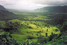
Jackmond's survey during 1977 - 1978 at Letolo covered an area from the south coast to gently sloping land 3 km inland to an elevation of 135m at the northern edge.
Within the 198.8-hectare (491-acre) area surveyed, approximately 3,000 features of human manufacture were recorded, including foundation platforms, 64.6 km of stone fences, primary and secondary walkways, and some 300 house sites.
[10] The archaeological survey showed that there were once literally hundreds of household units, which extended far inland beyond the mapped area, past the Pulemelei stone mound.
The two adzes were discovered in 1988 by Rhys Richards of the New Zealand High Commission in Samoa during examination of pottery sherds with archaeologist Helen M. Leach, fifteen years after the original site discovery.
In the 1940s, New Zealand anthropologist Derek Freeman, a schoolteacher in Samoa from April 1940 to November 1943,[6] studied earthmounds lying near the Tausala stream which enters the sea between Fagali'i and Vailele.
[1] Janet Davidson spent six months carrying out site surveys on Upolu (1965–1966) in Sasoa'a at Falefa Valley, Lalomanu village in the Aleipata district and at the government owned WSTEC plantation at Mulifanua.
The field work at Mt Olo Plantation was carried out at different periods over three years under the University of Utah Samoan Archaeological Programme.