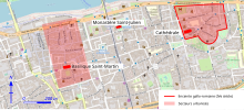
Arcis enclosure
Its construction undoubtedly dates back to the 11th or 12th century, after the building of the bridge over the Loire that ends in its northeast corner, but sources on its subject are scarce.
Its purpose was certainly defensive, but it also played a political role in the war of influence between the old city of Tours and the rapidly expanding town of Châteauneuf, one kilometer to the west.
[1] In the present case, however, this etymology is not certain, and the word may also symbolize the "urban reconquest" of a territory inhabited in Gallo-Roman times but abandoned in the Late Middle Ages.
At that time, Tours was an urbanized area with two very distinct entities, one of which was a growing nucleus around the Basilica of Saint-Martin to the west, protected in the first quarter of the 10th century by the Châteauneuf enclosure, but which it had largely overtaken.
There are probably four gates in the enclosure, two to the north, one of which is at the mouth of the bridge, one to the west and one to the south (Porte Saint-Étienne),[M 2] but their precise number and location may have varied over time.
[20][note 3] The western flank was lined by a moat[M 3] connected on one side to the Loire and on the other to the boire [fr] (backwater) to the south of the town, serving as much to drain the surrounding land as to protect the wall.
[10] The south-western corner of the Arcis enclosure seems to form an overhang, built at a later date, which can be identified on the Napoleonic cadastre by the different orientation of certain plots, and already represented in 1841 on a plan by Noël Champoiseau.
[23][24] The western ditch has been filled in, but anomalies in some of the buildings occupying its site (difference in level in the bays, cracks) and a tree whose trunk has sunk into the ground bear witness to the successive settling of the backfill.