Arkaim
[3] The construction of Arkaim is attributed to the early Proto-Indo-Iranian-speakers of the Sintashta culture, which some scholars believe represents the proto-Indo-Iranians before their split into different groups and migration to Central Asia and from there to the Iranian plateau, Indian subcontinent and other parts of Eurasia.
[4] In the summer of 1987 a team of archaeologists headed by Gennady Zdanovich was sent to examine the archaeological value of the valley at the confluence of the Bolshaya Karaganka and Utyaganka rivers, in the south of Chelyabinsk Oblast or the Southern Ural region, where the construction of a reservoir had begun the previous autumn.
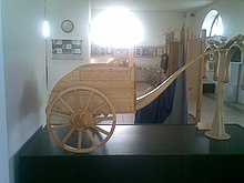
[3] The near Sintashta culture, excavated in that decade, yielded the remains of an early chariot with horses, making apparent that the southern Urals had been a key location in the development of technology and complex civilisation.
[5] The struggle to rescue the site was difficult since the reservoir project was overseen by the then all-powerful Ministry of Water Resources of the Soviet Union.
In March 1989 the Praesidium of the Urals Branch of the Academy of Sciences of the Soviet Union formally established a scientific laboratory for the study of the ancient civilisation of Chelyabinsk Oblast.
[6] Arkaim was a circular stronghold consisting of two concentric bastions made of adobe with timber frames, and covered with unfired clay bricks.
According to historian V. A. Shnirelman, "All the evidence suggests that the settlement had been built to a common plan, which is indicative of a society with a developed social structure and local leaders with high authority.
"[5] Scholars have identified the structure of Arkaim as the cities built "reproducing the model of the universe" described in ancient Indo-Aryan/Iranian spiritual literature, the Vedas and the Avesta.
More than twenty other structures built according to similar patterns have been found in a larger area spanning from the southern Urals' region to the north of Kazakhstan, forming the so-called "Land of Towns".
The dwellings of the inner ring numbered twenty-seven, arranged along the inner wall, with doors opening towards the central square, which was about 25 by 27 metres (82 by 89 feet) in area.
[14] The discovery of Arkaim and the Land of Towns has fueled the growth of schools of thought among Russian Rodnovers, Roerichians, Assianists, Zoroastrians, Hindus and others which regard the archaeological site as the second homeland of the Indo-Europeans, who originally dwelt in Arctic regions [citation needed] and migrated southwards when the weather there became glacial, then spreading from Siberia to the south and the west, eventually developing into other civilisations.