Azimuth
When used as a celestial coordinate, the azimuth is the horizontal direction of a star or other astronomical object in the sky.
The star is the point of interest, the reference plane is the local area (e.g. a circular area with a 5 km radius at sea level) around an observer on Earth's surface, and the reference vector points to true north.
The first known record in any Western language is in Spanish in the 1270s in an astronomy book that was largely derived from Arabic sources, the Libros del saber de astronomía commissioned by King Alfonso X of Castile.
In land navigation, azimuth is usually denoted alpha, α, and defined as a horizontal angle measured clockwise from a north base line or meridian.
[5][6] Azimuth has also been more generally defined as a horizontal angle measured clockwise from any fixed reference plane or easily established base direction line.
Moving clockwise on a 360 degree circle, east has azimuth 90°, south 180°, and west 270°.
Quite commonly, azimuths or compass bearings are stated in a system in which either north or south can be the zero, and the angle may be measured clockwise or anticlockwise from the zero.
If the bearing happens to be exactly in the direction of one of the cardinal points, a different notation, e.g. "due east", is used instead.
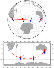
We can get a fair approximation by assuming the Earth is a sphere, in which case the azimuth α is given by A better approximation assumes the Earth is a slightly-squashed sphere (an oblate spheroid); azimuth then has at least two very slightly different meanings.
[10] Normal-section azimuth can be calculated as follows:[citation needed] where f is the flattening and e the eccentricity for the chosen spheroid (e.g., 1⁄298.257223563 for WGS84).
If φ1 = 0 then To calculate the azimuth of the Sun or a star given its declination and hour angle at a specific location, modify the formula for a spherical Earth.
The opposite problem occurs when the coordinates (X1, Y1) of one point, the distance D, and the azimuth α to another point (X2, Y2) are known, one can calculate its coordinates: This is typically used in triangulation and azimuth identification (AzID), especially in radar applications.