Battista Beccario
Both of the Beccario maps are smaller than the "normal portolan", i.e. they omit the Black Sea and most of the east Mediterranean.
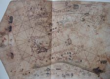
In the 1426 Munich map, Beccario seems to derive many of the stylings of the Majorcan cartographic school, being the first Italian map replete with inland features [8] Although it seems like a "normal portolan", it covers an area a bit smaller than its predecessors, e.g. it omits most of northern Europe and the Baltics, and less of the west African coast.
Among its novel features, Beccario depicts the winds and the Pole star on colored round disks on the edge of the map, a custom later widely adopted in portolan charts.
[9] Beccario's 1435 Parma map is similar to the earlier in its range, but exhibits the traditional sparse Italian school style, nautical-focused, omitting most inland details and illustrations, with only a few cities depicted (Genoa, Avignon, Santiago de Compostela, Tlemcen), the rest (if noted) reduced to labels.
[11] Prior to the discovery of the 1424 map of Zuane Pizzigano, Beccario's 1435 Parma map was believed to be the first to depict the legendary Atlantic islands of Antillia, Satanazes (Satanagio), Royllo and Tanmar, famously labelling the group as Insulle a nove repte (read: repte = repertae, "islands newly reported").