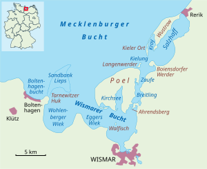
Bay of Wismar
Wismar bay is considered one of the finest natural harbors[2] on the Baltic, and served as the destination for much seaborne shipping until circa the 1910s when its minimum depths of 5 meters (16 ft) became too shallow for larger more modern ships.
Today, because of the shallow sheltered waters the bay is the subject of much research via underwater archeology.
There are four lobe like parts of the Bay of Wismar which are themselves bays on its southern shores, each separated by a north intruding headland from the others (see maps at right) and a broad channel running northwest to southeast parallel to the line formed by the tips of the four bounding headlands.
[3] All of the waters are bounded by Poel Island on one side—a large mainly agricultural and recreational island sheltering the most easterly parts of bay (the inner Bay of Wismar and the small coastal seaport) along most of its northern edge.
The northern tip of the island in a line westerly to the headland of Großklützhöved (3.35 mi (5.39 km) north[3] of the village of Klütz) forms the mouth of the bay.