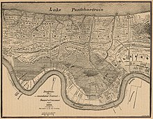
Bayou Metairie
With time, the course of the river shifted to its present day location, leaving behind a stranded waterway that was Bayou Metairie.
Its river banks of its past course remained as the long narrow strip of higher ground that is known as the Metairie - Gentilly Ridge.
[1] This ridge as it followed Bayou Metairie was as much as a mile wide at its beginning, becoming much narrower as it progressed eastward, with a height of approximately seven feet.
[2] Water flow from the Mississippi River into Bayou Metairie was intermittent until approximately the year 1700 when it had ceased completely.
[4] Subsequently, the land on the ridge was mostly used for small farms and gardens, being fertile soil on high ground, in centuries past of the region.