Bears Ears National Monument
The monument protects 1,351,849 acres (2,112.264 sq mi; 5,470.74 km2) of public land surrounding the Bears Ears—a pair of buttes—and the Indian Creek corridor rock climbing area.
The names are listed in the presidential proclamation as "Hoon’Naqvut, Shash Jáa [sic],[2] Kwiyaghatʉ Nükavachi/Kwiyagatu Nukavachi, Ansh An Lashokdiwe"—all four mean "Bears Ears".
The monument also includes the Valley of the Gods to the south, the western part of the Manti-La Sal National Forest's Monticello unit, and the Dark Canyon Wilderness to the north and west.
The monument also includes the Valley of the Gods to the south, the western part of the Manti-La Sal National Forest's Monticello unit, and the Dark Canyon Wilderness to the north and west.
Capped by Wingate Sandstone, the buttes and surroundings have long been held as sacred or significant by a number of the region's Native American tribes.
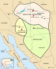
[26]: 8, 9 Archaeological sites of prehistoric American southwestern culture dating 3,000 to 2,000 ago, contained a large number of baskets used for storage of corn and for burial.
The "complex cultural history" of these early farmers is visible in the remains of "single family dwellings, granaries, kivas, towers, and large villages and roads linking them together".
[3] Along Comb Ridge (Navajo: Tséyíkʼáán)[32][33]—a one-mile wide and 80-mile long "dramatic geologic fold"[33] with some of the best-preserved cliff dwellings—Ancestral Puebloans lived in the "alcoves and grew corn"[33] from about AD 900 to 1350.
A 2015 article in Nature called it "one of the greatest vanishing acts documented in human history" in which the San Juan region "became almost instantly a ghost land.
[45] In 1943, western historian and novelist David Lavender (1910–2003) described the area in his book One Man's West[46] as "a million and a quarter acres of staggering desolation between the San Juan and Colorado rivers, a vast triangle of land that even today is not completely mapped.
"[51] Senator Bennett invited Native people in San Juan County, Utah to engage in discussions on public land management of Bears Ears.
The "ancestral lands of Bears Ears lie outside reservation boundaries" but "hold special historical and spiritual significance for regional Native people".
[52] The Utah Tribal Leaders Association began regular discussions on land-use negotiations to "advance Native American interests on public lands".
[54] The Navajo Nation and San Juan County signed a Memorandum of Understanding to "identify conservation areas, set aside wilderness, propose mineral zones, and pursue economic development opportunities.
[61][62][63] In October 2015, the BEITC submitted a proposal to President Barack Obama, seeking the designation of 1,900,000 acres (770,000 ha) as a national monument which would include Cedar Mesa, Indian Creek, White Canyon, Abajo Mountains, Comb Ridge, Valley of the Gods, and the confluence of the San Juan and Colorado Rivers.
[64][65] The Southern Utah Wilderness Alliance described how a "historic coalition of Native American Tribes" requested for the Bears Ears National Monument designation to "provide them with co-management authority to protect their ancestral homelands".
[24]: 1 [49] In 2009, FBI and Bureau of Land Management (BLM) agents raided 16 homes in Blanding, following a two-year federal investigation and the indictment of 24 people for stealing, receiving or trying to sell Native American artifacts[50] from the hundreds of archaeological sites in the area.
[12][3] The intertribal coalition had proposed to include several areas that did not make it into the final monument designation like the Abajo Mountains (also called the Blue Mountains); the lower reach of Allen Canyon; Black Mesa; a "large, arcing strip of land" next to the Glen Canyon National Recreation Area, surrounding Mancos Mesa; Raplee Anticline, and "most of Lime Ridge between Mexican Hat and Comb Ridge.
[45] The monument has divided people in Blanding, Bluff and other Utah towns that skirt its border, and some members of families that are split on the issue have simply stopped speaking to each other.
Signs reading "#rescindbearsears" stretch across gas stations and front lawns, which are strategically avoided by people who have taken to wearing pro-monument T-shirts.The monument is in San Juan County—a county of 8,000-square-miles with a sparse population of 16,895.
[citation needed] In a May 2017 interview in The New York Times 52-year-old James Adakai, "whose Navajo ancestors lived and hunted here for generations" described how, "We fought, we won the century-year-old fight: the monument.
"[77] Arizona state Representative Eric Descheenie, a member of the Navajo Nation, said "At the end of the day, there's only a certain place in this entire world, on earth, where we as indigenous peoples belong.
Some researchers and observers said that it was possible that president-elect Donald Trump or other Republicans might make an attempt to withdraw the designation and abolish the monument, though there was no clear legal mechanism for the president to do so unilaterally.
[79] A lawsuit against the FBI and BLM for its "heavy-handed and overzealous" looting raid in 2009, was rejected in February 2017 but "remains a point of contention for people in [Blanding], many of whom are also frustrated by the creation of the nearby Bears Ears National Monument.
[90][91] On February 21, 2017, the Southern Utah Wilderness Alliance announced that it would begin a statewide television advertisement campaign to build support for Bears Ears National Monument.
[93] The order directed the department to consider the Antiquities Act "requirement that reservations of land not exceed 'the smallest area compatible with the proper care and management of the objects to be protected.'"
[6][102] The monument's reduction was seen as a victory for Republican officials and energy companies with mining leases for fossil fuel and uranium deposits,[103] and a defeat for environmentalists and Native American tribes.
[104][105] According to Interior Department emails that The New York Times obtained following a successful lawsuit, gaining access to potential coal reserves in the Grand Staircase–Escalante's Kaiparowits Plateau was one of the central factors in Trump's decision to shrink the size of the Monument by approximately 47%.
[101][96] The largest previous reduction by acreage was President Woodrow Wilson's 1915 removal of 299,370 acres (121,150 ha) from the Mount Olympus National Monument established by Theodore Roosevelt in 1909.
On his first day in office, President Joe Biden signed an executive order calling for a review of the reduction of the Bears Ears and Grand Staircase–Escalante monuments.