Berkeley Pier
When constructed in 1926, the pier extended 3.5 miles (5.6 km)[1] into San Francisco Bay from the end of University Avenue.
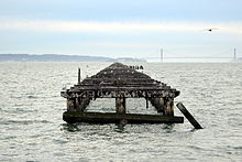
Due to extensive filling of the bay and the creation of the Berkeley Marina, it presently extends only 2.5 miles (4.0 km).
One was located at the foot of Addison Street one block south of University Avenue and served the Standard Soap Company, a major regional soap-making factory.
The other, the Jacobs and Heywood Wharf, was located several blocks north of University Avenue at the foot of Delaware Street, used as a general freight transshipment point.
It was built out from the foot of University Avenue, extending about 3.5 miles (5.6 km) into the Bay (measured from the original shoreline).
[13] From its opening in 1927 to 1937, the Pier served as an integral part of the Lincoln Highway (the first road across America), and then subsequently U.S. Route 40.
The ferry line shut down on October 16, 1937,[14] 11 months after the Bay Bridge opened to auto traffic.